
Elevation 4,100 m | ||
 | ||
Shoukat ali mahar ghotki sindh at high battle ground in world burzil pass astore 03322920733
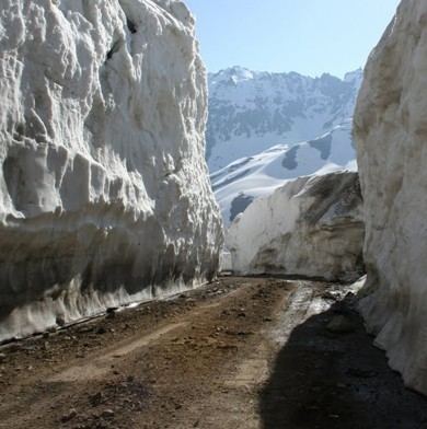
The Burzil Pass (el. 4,100 m (13,500 ft)) is an ancient pass and caravan route between Srinagar in Kashmir and Gilgit. This route was active up to Pakistan's independence. The pass lies close to the Line of Control demarcating India and Pakistan, which has since closed the Burzil. The crest of the pass is wide and covered in summer with alpine grass vegetation. The Astor river originates from western slopes of the pass.
Contents
- Shoukat ali mahar ghotki sindh at high battle ground in world burzil pass astore 03322920733
- Map of Burzil Pass
- References
Map of Burzil Pass
It is the oldest route connecting Gilgit with Srinagar and Skardu through Deosai Plateau. The travellers used horses and ponies to cross the pass. On the beginning of 20th century a hut of post couriers was situated on the crest of the Pass. They brought mail from India to China.
Gilgit is some 367 km (228 mi) from Srinagar by road over the Burzil pass above the northern banks of Wular Lake and Gurez.
From Astore to Burzil Pass Road following main places in route:-
Gorikot, Astore River Bridge, Maikaal, Dad Khiran, Chilam Chowki,
River Neelum are also start from Brzil Nor.