
Population 158 (2006 census) Local time Tuesday 8:32 PM | Postcode(s) 3352 Postal code 3352 | |
 | ||
LGA(s) City of BallaratPyrenees Shire Weather 20°C, Wind SE at 21 km/h, 52% Humidity | ||
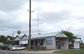
Burrumbeet is a town in western Victoria, Australia. The town is located on the Western Highway, 136 kilometres (85 mi) west of the state capital, Melbourne and 24 kilometres (15 mi) west of the regional centre, Ballarat. At the 2006 census, Burrumbeet and the surrounding area had a population of 158.
Contents
Map of Burrumbeet VIC 3352, Australia
Lake Burrumbeet, a large but shallow eutrophic lake, is located nearby.
History
Burrumbeet Post Office opened on 1 September 1857 and closed in 1978.
Today
Burrumbeet has a Thoroughbred horse racing club, the Burrumbeet Park & Windermere Racing Club, which holds one race meeting a year, the Burrumbeet Cup meeting on New Years Day.
References
Burrumbeet, Victoria Wikipedia(Text) CC BY-SA