
Province Ontario | ||
 | ||
Similar Trent–Severn Waterway, Kawartha Lakes, Peterborough Lift Lock, Petroglyphs Provincial Park, Balsam Lake | ||
Burleigh falls selwyn ontario
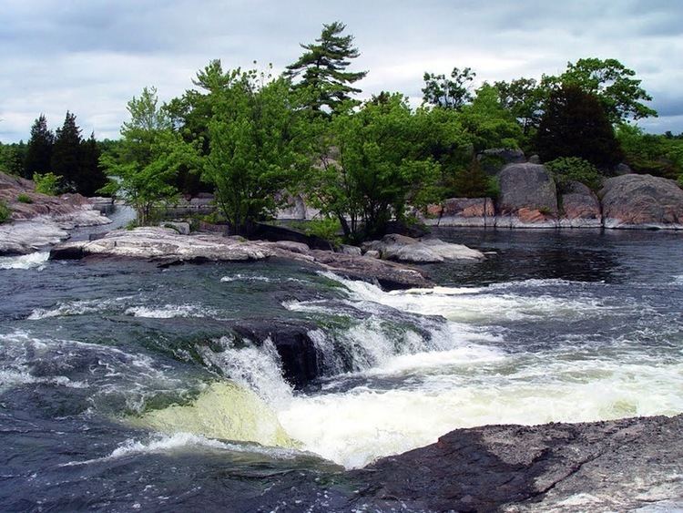
Burleigh Falls is both a geological feature and a small community in Peterborough County, Ontario, Canada. The falls form the boundary between the municipality of Trent Lakes to the north and the municipality of Selwyn to the south.
Contents
- Burleigh falls selwyn ontario
- Map of Burleigh Falls Selwyn ON Canada
- Walking around burleigh falls ontario canada
- Burleigh Falls bridge
- Lock 28
- Control dam
- Village of Burleigh Falls
- Outdoor activities
- References
Map of Burleigh Falls, Selwyn, ON, Canada
The falls (more accurately described as a chute or cascade, since the drop in water level is more horizontal than vertical) are created by a narrowing in the flow of water between Lovesick Lake and Lower Buckhorn Lake on the west and Stoney Lake to the east. At one time the landform was known as the "Burleigh chute".
Walking around burleigh falls ontario canada
Burleigh Falls bridge
The bridge over the upper part of the cascade is part of Highway 28, a major north-south transportation route. Although the south and north shores are at one point less than 100m apart, the area is so riddled with large lakes and rivers that before the bridge was built the shortest distance by land between the two points was at that time more than 70 km., much of it without roads. Before the Kings Post Truss style iron bridge was built in the 1860s, travelers managed by crossing Stony Lake, by boat in the summer, and across the ice in winter.
Lock 28
In historical times, because of the large number of lakes and the rocky uneven terrain, most travel in central Ontario took place on water. An extensive system of locks and dams, the Trent-Severn Waterway, which connects Lake Ontario to Georgian Bay, was built to facilitate this travel. At Burleigh Falls, the large, rapidly moving flow, cascading over and around rocks, was a serious barrier to transportation, so Lock 28 was built just to the north, allowing boat traffic to bypass the falls. Commonly known as the Lovesick Lock, it is composed of two 4m flights, and the lock canal, about 190m in length, was blasted through solid granite. The lock was completed in 1887. Limestone around this area was used in the construction of several nearby locks.
Control dam
Also as part of the Trent-Severn Waterway, a long control dam was built just above the falls. The purpose of this dam is to regulate the water level on Lovesick Lake, both keeping it navigable for larger boats and ensuring sufficient water to operate the lock.
Village of Burleigh Falls
With the building of the bridge and lock, a village, also known as Burleigh Falls, developed on the nearby shores, with businesses which supply amenities to lumberman, steamship passengers, various other travelers by road and water, and in more recent years to tourists and the thousands of cottagers on the two large nearby lakes.
On the 11 acre Burleigh Island, a hotel was built by John Holmes in 1857. The first post office opened in the village in 1877.
At Burleigh Falls there is a public wharf.
Outdoor activities
Recreational boating and in particular canoeing have long been popular around Burleigh Falls. In 1974 the local Kawartha Non-Status Indian and Metis Association started the Burleigh Falls Canoe Company, and began manufacturing cedar-strip canoes in response for the demand for these boats. The area has been popular with fishermen since pioneers days. More recently kayaking enthusiasts have arrived to enjoy the rapids.