
Congressional district At-large Website www.co.burleigh.nd.us Founded 1873 | Area 4,320 km² Population 88,457 (2013) | |
 | ||
Colleges and Universities Bismarck State College, University of Mary, United Tribes Technical, Hair Academy, Aakers Business College Points of interest North Dakota Heritage, Dakota Zoo, Fort Abraham Lincoln, North Dakota State Cap, Apple Creek Country | ||
Burleigh County is a county located in the U.S. state of North Dakota. As of the 2010 census, the population was 81,308, making it the second-most populous county in North Dakota. Its county seat is Bismarck, the state capital. The county was created on January 4, 1873 and later organized on July 16.
Contents
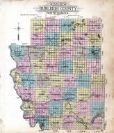
- Map of Burleigh County ND USA
- Geography
- Major highways
- Adjacent counties
- National protected areas
- Demographics
- Cities
- Census designated places
- Unincorporated communities
- References
Map of Burleigh County, ND, USA
Burleigh County is included in the Bismarck, ND Metropolitan Statistical Area, commonly called "Bismarck–Mandan".
Geography
According to the U.S. Census Bureau, the county has a total area of 1,668 square miles (4,320 km2), of which 1,633 square miles (4,230 km2) is land and 36 square miles (93 km2) (2.1%) is water.
Major highways
Adjacent counties
National protected areas
Demographics
As of the 2010 United States Census, there were 81,308 people, 33,976 households, and 21,213 families residing in the county. The population density was 49.8 inhabitants per square mile (19.2/km2). There were 35,754 housing units at an average density of 21.9 per square mile (8.5/km2). The racial makeup of the county was 93.0% white, 4.2% American Indian, 0.6% black or African American, 0.5% Asian, 0.3% from other races, and 1.4% from two or more races. Those of Hispanic or Latino origin made up 1.2% of the population. In terms of ancestry, 61.0% were German, 21.1% were Norwegian, 8.1% were Russian, 6.8% were Irish, and 2.6% were American.
Of the 33,976 households, 29.0% had children under the age of 18 living with them, 50.2% were married couples living together, 8.7% had a female householder with no husband present, 37.6% were non-families, and 30.5% of all households were made up of individuals. The average household size was 2.31 and the average family size was 2.90. The median age was 37.3 years.
The median income for a household in the county was $53,465 and the median income for a family was $71,103. Males had a median income of $44,944 versus $31,943 for females. The per capita income for the county was $28,784. About 6.3% of families and 9.4% of the population were below the poverty line, including 11.6% of those under age 18 and 11.0% of those age 65 or over.