
OS grid reference SU680706 Sovereign state United Kingdom | Post town READING Dialling code 0118 | |
 | ||
Weather 6°C, Wind W at 18 km/h, 83% Humidity | ||
Train spotting at burghfield bridge and at soutucote jn
Burghfield Bridge is a bridge and a hamlet in the Parish of Burghfield (where the 2011 Census population was included), which stands to the south of it in the English county of Berkshire. The settlement is situated between the village of Burghfield and the Reading suburb of Southcote. In 2006, the Reading Chronicle named the hamlet as one of the most desirable (and thus most expensive) places to live in the Reading area.
Contents
- Train spotting at burghfield bridge and at soutucote jn
- The cunning man in burghfield bridge flooded
- The bridge
- The Cunning Man
- World War II
- Places of interest
- Transport
- Nearby towns
- Nearby villages
- References
The cunning man in burghfield bridge flooded
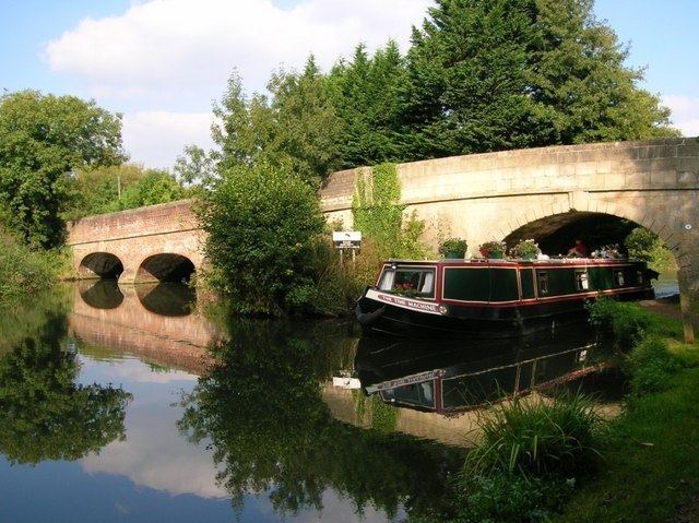
The bridge
The hamlet is so-called due to the bridge crossing the River Kennet (now part of the Kennet and Avon Canal). The river was first crossed in the area in the thirteenth century by the Lord of the Manor, Matthew. The original Burghfield Bridge was built by the De Burghfield family, but they had arguments with King Edward I over who should repair it. There was a minor skirmish there after the First Battle of Newbury in 1643.
The current bridge was built c.1812 and is a Grade II listed building.
The Cunning Man
Burghfield Bridge is involved in the local legend of the Cunning Man. Various stories exist regarding the legend, citing the Cunning Man as a wizard from nearby Tadley, who was able to heal both ailments and broken relationships. Another explanation is that a local building (now the Peter Pan Café) was built by a cunning man using bricks placed on their sides - so to use less building materials. The story lends its name to the local pub/restaurant, part of the Mitchells and Butlers "Vintage Inns" brand.
World War II
In the early Part of World War II, several anti-invasion measures were installed across the borough, including a fortified house at Burghfield Bridge. Iverne House is situated 100m to the south of the Bridge and was originally a stables. This was converted into a two storey shell-proof infantry strongpoint around 1941/42. There are gun ports clearly visible from the main Burghfield/Reading Road. The building was converted to a private dwelling in 1994
Places of interest
Burghfield Bridge is the location of Keynote Studios, a recording facility that has recently recorded the follow-up to The Race's 2006 album "Be Your Alibi".
There is a disused water mill, Burghfield Mill, located alongside the River Kennet and to the West of Burghfield Bridge, now converted to residential apartments. Burghfield Lock lies nearby on the Kennet and Avon Canal.
Transport
Burghfield Bridge is served by Reading Buses routes 2, 2a and 2b. The hamlet is located near to Reading services on the M4 motorway, although the nearest access point to the road (junction 11) is located 2.5 miles (4.0 km) to the south-east. The nearest railway stations to the hamlet are Theale railway station and Reading West railway station. Both stations are located a little more than 2 miles (3.2 km) away.
Nearby towns
Reading
Nearby villages
Burghfield, Burghfield Common, Pingewood, Southcote