
Official name Burdekin Falls Dam Location North Queensland Opening date 1987 Area 220 km² Height 55 m Owner SunWater | Country Australia Purpose Irrigation Type of dam Gravity dam Catchment area 114,220 km² Opened 1987 Impound Burdekin River | |
 | ||
Similar Burdekin River, Ross River Dam, Lake Julius, Peter Faust Dam, Wuruma Dam | ||
The Burdekin Dam, officially the Burdekin Falls Dam, is a concrete gravity dam with an uncontrolled spillway across the Burdekin River, located south west of Ayr, and Home Hill in North Queensland, Australia. Built for the purpose of irrigation, the reservoir, called Lake Dalrymple. Burdekin Dam is managed by SunWater. Water from the reservoir is also used to replenish downstream aquifers.
Contents
- Map of Dalrymple Lake Queensland Australia
- Location and features
- History
- Irrigation
- Proposed hydroelectricity
- Boating
- Fauna and flora
- References
Map of Dalrymple Lake, Queensland, Australia
Location and features
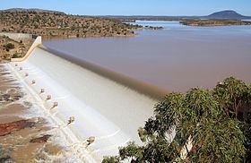
The dam wall is 876 metres (2,874 ft) long and has a 504-metre (1,654 ft) spillway, and a drop of 37 metres (121 ft). The reservoir holds 1,860,000 megalitres (410×109 imp gal; 490×109 US gal) at full capacity. The design allows for future storage capacity increases and potential for hydro-electricity generation. Plans are in place to increase the safety of this dam in an extreme rainfall event by increasing the spillway capacity. This project is scheduled for completion over the next 5 to 20 years.
The catchment area for the dam extends north to the Seaview Range west of Ingham, south to the Drummond Range near Alpha through the Suttor and Belyando Rivers, southeast to the coastal ranges west of Mackay, and west beyond Charters Towers to the Lolworth, Montgomery and Stopem Blockem Ranges through the Clarke River.
History
Construction of the dam began in 1984. It was completed by Leighton Holdings in 1987 and is the largest dam in the state, with a capacity four times that of Sydney Harbour. Burdekin Dam filled after the wet season in 1988.
Irrigation
The Burdekin River Irrigation Area was granted approval in 1980. It is Queensland's largest land and water conservation scheme. In 2007, the scheme was supplying 103,000 ha of land located about 200 kilometres (120 mi) inland from Townsville with water to grow a range of crops including sugar cane, cotton and rice.
Proposed hydroelectricity
Stanwell Corporation has begun a feasibility study into a proposed 37 megawatts (50,000 hp) hydroelectric power station below the Burdekin Dam wall. It is proposed it would be capable of producing 125,000 megawatt-hours (450,000 GJ) annually, enough to power more than 9,500 homes each year.
Boating
There are no boating restrictions, with a single boat ramp located near the dam wall. Water in the dam is often muddied with unsettled sediment long after the rains have washed it into the lake. This not only makes angling difficult but also means boating can be hazardous at high speeds due to the presence of submerged rocks.
Fauna and flora
The dam has been stocked with sleepy cod, sooty grunter and barramundi. Numerous other species are present naturally, including forktail catfish, spangled perch, eel-tailed catfish, long tom, golden perch and archer fish. A Stocked Impoundment Permit is required to fish in the dam. Red-claw crayfish and freshwater crocodiles are also found in the dam. Saltwater crocodiles may also inhabit the Lake Dalrymple reaches of the dam.