
Basin countries Australia Average depth 8.9 m (29 ft) Area 12.55 km² Mean depth 8.9 m Lake type Reservoir | Surface area 1,255 ha (3,100 acres) Max. depth 25.2 m (83 ft) Surface elevation 224 m | |
 | ||
Water volume 107,500 ML (3,800×10^ cu ft) Similar Lake Moondarra, Neil Turner Weir, Wuruma Dam, Mount Crosby Weir, Koombooloomba Dam | ||
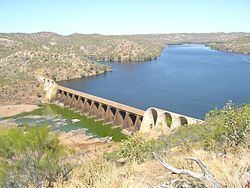
Lake Julius was formed following the construction of Julius Dam in 1976 for irrigation and town water storage. The dam wall is located just below the junction of the Leichhardt River and Paroo Creek some 70 kilometres (43 mi) North East of Mount Isa. It has a full supply capacity of 127,000 megalitres (4,500×10^6 cu ft), a surface area of 1,255 hectares (3,100 acres) with an average depth of 8.9 metres (29 ft).
Map of Lake Julius, Queensland, Australia
The dam is unique in Queensland and is a concrete multiple arch and buttress type structure, with the spillway discharging over the tops of the arches. The spillway crest is 18.3 metres (60 ft) above bed level. The arch barrels, founded on a triangular arch base, are constructed in independent arch rings and are hinged at buttress springing lines. The spillway is a precast superstructure and the dissipation slab at ground level is post tensioned to the foundation rock.
The dam has a total storage capacity of 107,500 megalitres (3,800×10^6 cu ft), and has a full supply level of 223.54m AHD
SunWater is undertaking a dam spillway capacity upgrade program.