
 | ||
Similar Klang Gates Dam, Mount Nuang, Klang Gates Quartz Ri, Sin Sze Si Ya Temple, Bukit Broga | ||
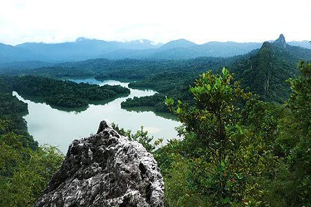
Hiking bukit tabur aerial view
Bukit Tabur is a hill located in Selangor, Malaysia. It is also known locally as Bukit Hangus. The hill is very prominent as it is part of Klang Gates Quartz Ridge and can be seen from the Kuala Lumpur Middle Ring Road 2. The hill, which is less than 500 metres, is a quartz ridge. Climbers enter the hiking trail via Kampung Klang Gates, 50 metres from the gates of the Klang Gates Dam, at the back of Taman Melawati for a 3-4 hour climb. The Gombak Forest Reserve and Klang Gates Dam are beside the hill. The peak offers view of the dam and panoramic views of Kuala Lumpur from the north. Several endemic species of plant such as Aleisanthia rupestris are known to grow here.
Contents
- Hiking bukit tabur aerial view
- Map of Bukit Tabur 53100 Selangor Malaysia
- Gopro hero3 bukit tabur climb
- References
Map of Bukit Tabur, 53100, Selangor, Malaysia
The hiking trail to Bukit Tabur can be found at 3°14′1″N 101°44′55″E.
Bukit Tabur is divided into the eastern and western section by the dam. Most hikers are familiar with the western section. The eastern side offers more challenging hikes but is said to be steeper and riskier if unfamiliar with the trail.
There has been a series of accidents on the trail including several fatal mishaps. It is likely that more restrictions will be imposed on hikers on this trail.