
Mountain type Cinder cone Last eruption Unknown Prominence 620 m | Elevation 620 m | |
 | ||
Similar Mount Makaturing, Camiguin de Babuyanes, Babuyan Claro Volcano, Cagua Volcano, Didicas Volcano | ||
Bud Dajo (Tausug: Būd Dahu; Spanish: Bud Dajó), is one of the cinder cones that make up the island of Jolo and part of the Jolo Volcanic Group in the Republic of the Philippines. The extinct volcano is located 8 kilometres (5.0 mi) southeast from the town of Jolo in Sulu province. The mountain and adjacent lands were declared as Mount Dajo National Park in 1938.
Contents
- Map of Bud Dajo Patikul Sulu Philippines
- Physical features
- Geology
- 1641
- 1897
- PHIVOLCS monitoring activity
- Mount Dajo National Park
- Fauna
- Historical relevance
- References
Map of Bud Dajo, Patikul, Sulu, Philippines
Physical features
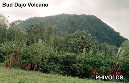
The cinder cone has an elevation of 620 metres (2,030 ft) with a base diameter of 9.5 kilometres (5.9 mi). On the summit of the mountain is 0.5 kilometres (0.31 mi) crater that is breached to the southwest. The other volcanic edifices adjacent to Bud Dajo are: Matanding, located northeast of the Bud Dajo with an elevation of 400 metres (1,300 ft) asl; Guimba, east and elevation of 482 metres (1,581 ft) asl; and Sungal, southeast which is 518 metres (1,699 ft) asl.
Geology
The basaltic volcanic cone is part of Zamboanga-Sulu volcanic arc.
1641
Two volcanoes falsely attributed to the eruption on January 4, 1641 which engulfed southern Philippines in darkness. Further studies later found the eruption to have come from Parker Volcano in Cotabato province.
1897
The earthquake and subsequent tsunami on September 21, 1897 that devastated the Southern Philippines was believed to be from a submarine eruption therefore excludes Bud Dajo.
PHIVOLCS monitoring activity
A short-term monitoring (seismic and visuals) surveys were conducted by the Philippine Institute of Volcanology and Seismology in 1993 and in 1997 on the mountain. No unusual activities were observed within the vicinity of the volcano.
Mount Dajo National Park
The mountain and surrounding areas were declared as a national park by Proclamation No. 261 on February 28, 1938 encompassing 213 hectares (530 acres) of land. Recent reports have shown that the mountain is very deforested with few remaining forest cover usually on the steep ridges. The game refuge is not currently listed as a protected area under the National Integrated Protected Areas System (NIPAS) of the Department of Environment and Natural Resources (Philippines).
Fauna
Some vulnerable and endangered species, not necessarily endemic to the area, but can be found within the Mount Dajo National Park are (from BirdLife International):
- Grey imperial pigeon (Ducula pickeringii), Vulnerable
- Philippine cockatoo or the red-vented cockatoo (Cacatua haematuropygia), Critically endangered
- Sulu hornbill (Anthracoceros montani), Critically endangered
- Sulu woodpecker Dendrocopos ramsayi, Vulnerable
- Winchell's kingfisher or rufous-lored kingfisher (Todiramphus winchelli), Vulnerable
Historical relevance
The mountain was the site of the First Battle of Bud Dajo during the Moro Rebellion of the Philippine-American War in 1906, which culminated in the Moro Crater Massacre, the killing of over 600 villagers(mostly civilians) hiding on the crater of Bud Dajo. The five-day Second Battle of Bud Dajo in 1911 ended with less casualties through negotiations, persuading the majority to return home.