
Population 622 Sovereign state United Kingdom Local time Sunday 11:37 PM | OS grid reference ST692053 | |
 | ||
Weather 6°C, Wind W at 29 km/h, 77% Humidity | ||
Dorset views dorchester poundbury buckland newton 20 8 14
Buckland Newton is a village and civil parish in Dorset, England. It is situated in the West Dorset administrative district beneath the scarp slope of the Dorset Downs, 6 miles (9.7 km) south of Sherborne. In the 2011 census the civil parish had a population of 622.
Contents
- Dorset views dorchester poundbury buckland newton 20 8 14
- Map of Buckland Newton Dorchester UK
- Birdsong in the snow henley buckland newton dorset england
- References
Map of Buckland Newton, Dorchester, UK
The name 'Buckland' derives from bōc-land, Old English for 'charter land' or land with special privileges created by royal diploma, while 'Newton' is a more recent addition taken from Sturminster Newton, a nearby town.
The parish originally had five settlements, each with their own open field system: Buckland Newton, Brockhampton, Duntish, Henley (perhaps previously known as Knoll) and Minterne Parva, the last now part of Minterne Magna parish.
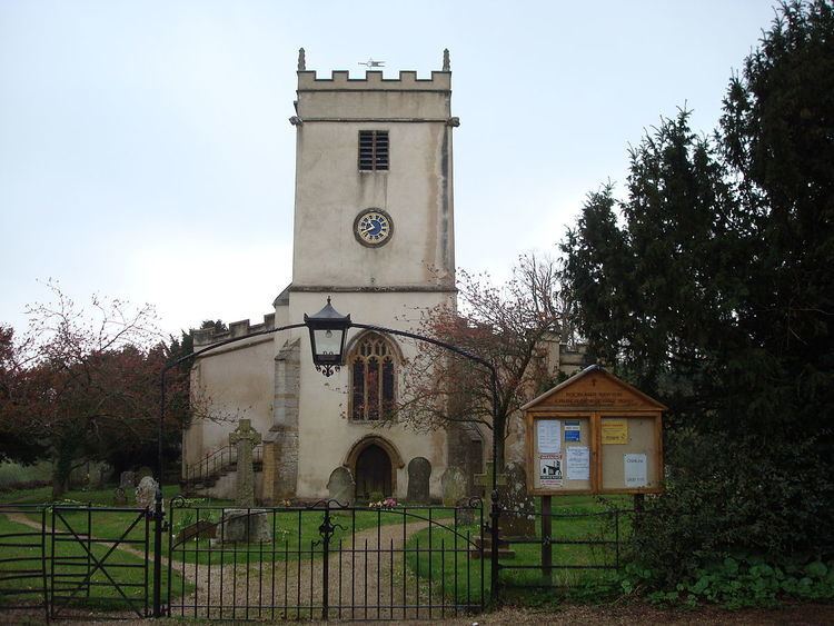
Although the Parish Church of the Holy Rood was restored in the 19th century, it has a 13th-century chancel and 15th-century nave, west tower and aisles, plus fragments of 12th-century sculpture which are evidence of an earlier structure. In 1980 the writer and literary director Roland Gant described Holy Rood as "a lovely church", but that the first impression it created was not favourable due to its exterior having been rendered in cement, "giving the Perpendicular square tower the look of a Foregn Legion fort".
Duntish Court, sited about 0.5 miles (0.80 km) north of the main village, was a compact, classical country house built in 1764 beside the main Weymouth to Bath turnpike road. Designed by Sir William Chambers, the Court—originally named Castle Hill—had notable plasterwork, grounds of 1,300 acres (530 ha) and played a role in the arrest of agricultural labourers in Dorset's 'Captain Swing' riots of 1830. It was demolished in 1965.
Prominent nearby hills at the top of the escarpment to the southeast include Ball Hill (251 m) and Lyscombe Hill (261 m) near the Dorsetshire Gap.
Amenities in the village include a shop, primary school and village hall.
The village lies within the Buckland Newton Hundred