
Intercommunality Vath Vielha Area 16.55 km² | Canton Nay-Ouest Population (2009) 922 | |
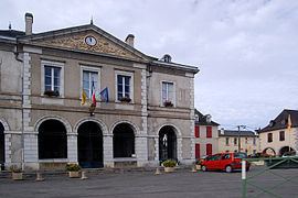 | ||
Bruges-Capbis-Mifaget is a commune in the Pyrénées-Atlantiques department in southwestern France.
Contents
Map of 64800 Bruges-Capbis-Mifaget, France
People from the commue are called "brugeois"'.
Geography
Bruges-Capbis-Mifaget is situated on 16.55 square kilometres (6.39 sq mi) of rolling hills in the far foothills of the Pyrenees.
Location
The commune is located on the east side of the department, 25 kilometres (16 mi) southeast of Pau.
Road Access
Bruges-Capbis-Mifaget is accessible by departmental routes 35, 232, 287, and 335.
Bordering communes
References
Bruges-Capbis-Mifaget Wikipedia(Text) CC BY-SA