
Location East Java, Indonesia Visitors 61,704 (in 2007) Area 502.8 km² Phone +62 341 491828 | Nearest city Malang Website bromotenggersemeru.org Province East Java Established October 14, 1982 | |
 | ||
Governing body Ministry of Environment and Forestry Address Ranupani, Senduro, Lumajang Regency, East Java, Indonesia Hours Open today · Open 24 hoursSaturdayOpen 24 hoursSundayOpen 24 hoursMondayOpen 24 hoursTuesdayOpen 24 hoursWednesdayOpen 24 hoursThursdayOpen 24 hoursFridayOpen 24 hours Similar Jiwa Jawa Bromo, Cemara Indah Hotel, Air Terjun Madakari, Hotel Bromo Permai 1, Lava View Lodge Hotel | ||
Bromo Tengger Semeru National Park is located in East Java, Indonesia, to the east of Malang and to the southeast of Surabaya, the capital of East Java. It is the only conservation area in Indonesia that has a sand sea, the Tengger Sand Sea (Indonesian: Laut Pasir Tengger), across which is the caldera of an ancient volcano (Tengger) from which four new volcanic cones have emerged. This unique feature covers a total area of 5,250 hectares at an altitude of about 2,100 m. The massif also contains the highest mountain in Java, Mount Semeru (3,676 m), four lakes and 50 rivers.
Contents
- The scenic bromo tengger semeru national park indonesia a bird s view
- VolcanismEdit
- EcosystemEdit
- Sub montane zone 750 1500 mEdit
- Montane zone 1500 2440 mEdit
- Subalpine zone above 2400 mEdit
- Flora and faunaEdit
- CultureEdit
- References
The Tengger Sand Sea has been protected since 1919. The Bromo Tengger Semeru National Park was declared a national park in 1982.
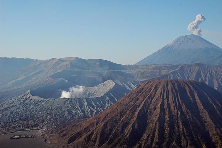
The scenic bromo tengger semeru national park indonesia a bird s view
VolcanismEdit
The volcanic complex of Tengger forms a condition where a new caldera of volcano forms inside a larger and more ancient caldera. There are five volcanoes inside the Tengger Caldera: Mount Bromo (2,329 m), Mount Batok (2,470 m), Mount Kursi (2,581 m), Mount Watangan (2,661 m), and Mount Widodaren (2,650 m). Mount Batok is the only peak that is no longer active, and is covered in casuarina (Indonesian: cemara) trees. Mount Widodaren, located beside Mount Batok, contains the cave Widodaren, which is considered sacred by local people.
The five volcanoes within the caldera are surrounded by a vast area of sand called the Tengger Sand Sea, which in turn is surrounded by a steep crater wall of the larger Tengger Caldera with height differences of about 200–600 meters. Other mountains around the Tengger caldera are: Mount Pananjakan (2,770 m) Mount Cemorolawang (2,227 m), Mount Lingker (2,278 m), Mount Pundak Lembu (2,635 m), Mount Jantur (2,705 m), Mount Ider-ider (2,527 m) and Mount Mungal (2,480 m). The peak of Mount Pananjakan is the most popular place to watch the entire volcanic complex of Tengger.
Further south in the national park, there is another volcanic complex called the Semeru Group or Jambangan Group. This area contains the highest peak of Java, Mount Semeru (3,676 m). Other mountains within this area are Mount Lanang (2,313 m), Mount Ayek-ayek (2,819 m), Mount Pangonan Cilik (2,833 m), Mount Keduwung (2,334 m), Mount Jambangan (3,020 m), Mount Gentong (1,951 m), Mount Kepolo (3,035 m), and Mount Malang (2,401 m). The Semeru forest area has many rivers that are former lava lines from Mount Semeru. The Semeru group is considered to be very productive, producing volcanic matters such as lava, volcanic ash, and hot cloud and spreading it to the surrounding area. The lower area is surrounded with fertile rice fields.
EcosystemEdit
According to height and temperature differences, the forests within the area can be classified into three zones:
Sub-montane zone (750 – 1,500 m)Edit
This zone is classified as a tropical rainforest. It can be found in the southern area of Semeru, East Semeru (Burno), and West Semeru (Patok Picis). This zone is dominated with plants of the families Fagaceae, Moraceae, Anacardiaceae, Sterculiaceae, and Rubiaceae. There are also liana trees, such as a variety from the genus Calamus, Piper, Asplenium, and Begonia, and other plants from the family Araceae, Poaceae, and Zingiberaceae. There are also 225 species of orchid in this area.
Montane zone (1,500 – 2,440 m)Edit
Plant life is greatly reduced in this area. Most of the species that grow in this area are pioneer species. There are also some wooden plants such as cemara (Casuarina junghuhniana), mentinggi gunung (Vaccinium varingifolium), kemlandingan gunung (Albizia lophantha), acacia bark (Acacia decurrens) and bottom plants such as Javanese edelweiss or senduro (Anaphalis longifongila and Anaphalis javanica), Imperata cylindrica, Pteris sp., Themeda sp. and Centella asiatica.
The Tengger Sand Sea in Tengger Caldera is a special ecosystem. The area is covered in volcanic sedimentation of sand from Mount Bromo activities. The resulting area is believed to be the only known desert-like area in Indonesia. The Tengger Sand Sea has been protected since 1919.
Subalpine zone (above 2,400 m)Edit
The flora that cover this area are mentinggi gunung (Vaccinium varingifolium) and cemara (Casuarina junghuhniana). Kemlandingan gunung (Albizia lophantha) and Javanese edelweiss can also be found growing in this zone.
On Mount Semeru, there is no plant life above the altitude of 3,100 m. This zone is covered in loose sandstones.
Flora and faunaEdit
Some endangered flora are protected in this park, such as Fagaceae, Moraceae, Sterculiaceae, Casuarina junghuhniana, Javanese edelweiss, and about 200 species of endemic orchids.
There is a relatively small diversity of fauna in the Bromo Tengger Semeru National Park. There are about 137 species of birds, 22 species of mammals and 4 species of reptiles protected in the national park. Examples are besra, green peafowl, Javan rusa, Sumatran dhole, crab-eating macaque, marbled cat and Javan leopard.
CultureEdit
The area in and around the park is inhabited by the Tengger people, one of the few significant Hindu communities remaining on the island of Java. The local religion is a remnant from the Majapahit era and therefore quite similar to that on Bali but with even more animist elements. The Tengger people are believed to be descendents of the Majapahit empire and were driven into the hills after mass arrival in the area of Muslim Madurese in the 19th century.