
Time zone BRT/BRST (UTC-3/-2) | Elevation 263 m (863 ft) Area 1,461 km² | |
 | ||
Microregion Rio Vermelho Microregion | ||
Britânia is a municipality in northwestern Goiás state, Brazil. The population was 5,073 (2007) in a total area of 1461.2 km².
Contents
- Map of BritC3A2nia State of GoiC3A1s Brazil
- Municipal boundaries
- Highway connections
- Demographic and political data
- Economic facts
- Health
- Education
- History
- References
Map of Brit%C3%A2nia - State of Goi%C3%A1s, Brazil
Municipal boundaries
Municipal boundaries:
Highway connections
A paved highway connects Britânia with Santa Fé de Goiás and Jussara. Connections with Goiânia are made by highways GO-060 / Trindade / Claudinápolis / GO-326 / Anicuns / Sanclerlândia / Novo Brasil / GO-324 / Jussara / BR-070 / Nova Trindade / GO-173.
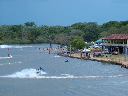
The main rivers are the Vermelho and the Araguaia. There are also several lakes, like the Tigrinho, Açará and the most important for tourist purposes, the Lago dos Tigres, which is used for fishing, water sports and swimming.
Demographic and political data
Economic facts
The economy is based on cattle raising, agriculture, commerce (58 units), and some small transformation industries (11 units). Britânia had a herd of 155,400 in 2006, with 90% being of the Nelore breed. The land is divided into large properties, which use little labor. Other important agricultural products are: rice, sesame seeds, manioc, and corn.
Health
Education
History
In 1953 Paulo Carlos Schmidt de Vasconcelos, from São Paulo, bought lands from the government and staked out lots in an endeavour called "Loteamento Lago dos Tigres" next to the lake with the same name. In 1959 another Paulista, Írio Spinar, bought the land and began to sell lots to farmers, who for the most part came from São Paulo or Paraná. The settlement grew and in 1958 it became a district of Jussara, later to become a municipality in 1963.