
River mouth Creuse95 m (312 ft) Length 84 km | Basin size 596 km (230 sq mi) Basin area 596 km² | |
 | ||
Main source in Aigurande385 m (1,263 ft) Discharge Average rate:3.23 m/s (114 cu ft/s) | ||
Orchestre les gars de la bouzanne
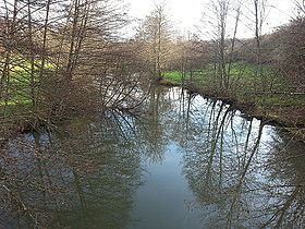
The Bouzanne (French: la Bouzanne) is an 84.5 kilometres (52.5 mi) long river in the Indre département of central France, and is a tributary of the Creuse. Its source is in the commune of Aigurande, 2.5 kilometres (1.6 mi) northwest of the town itself, near the hamlet of la Bouzanne. It flows generally northwest, going northwards from its source up to Arthon, then southwest to the confluence where it enters the Creuse at the right-hand side of the flow (with forwards being downstream), 1.3 kilometres (0.81 mi) southwest of the village centre of Le Pont-Chrétien-Chabenet.
Contents
- Orchestre les gars de la bouzanne
- Map of La Bouzanne Neuvy Saint SC3A9pulchre France
- Hub africa nicolas bouzanne tpf ingenierie
- Communes along its course
- References
Map of La Bouzanne, Neuvy-Saint-S%C3%A9pulchre, France
Hub africa nicolas bouzanne tpf ingenierie
Communes along its course
The following list is ordered from source to mouth : Aigurande, La Buxerette, Montchevrier, Cluis, Mouhers, Neuvy-Saint-Sépulchre, Tranzault, Lys-Saint-Georges, Buxières-d'Aillac, Jeu-les-Bois, Arthon, Velles, Tendu, Mosnay, Saint-Marcel, Chasseneuil, Le Pont-Chrétien-Chabenet