
Postal code 9545 Local time Friday 10:33 AM | Time zone CET (UTC+1) Area code 0599 Population 430 (2012) | |
 | ||
Weather 7°C, Wind S at 14 km/h, 75% Humidity Points of interest Fort Bourtange, De Baracquen, Synagoge | ||
Bourtange vlagtwedde groningen province netherlands europe
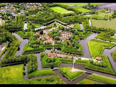
Bourtange ( [ˌbuːrˈtɑŋə]; Gronings: Boertang) is a village with a population of 430 in the municipality of Vlagtwedde in the Netherlands. It is situated in the region Westerwolde in the east of the province of Groningen near the German border. Fort Bourtange was built in 1593 during the Dutch Revolt and was used until 1851. The star fort was restored to its mid-18th-century state in 1960 and it is currently an open-air museum.
Contents
- Bourtange vlagtwedde groningen province netherlands europe
- Map of Bourtange Netherlands
- Etymology
- History
- Geography
- Demographics
- References
Map of Bourtange, Netherlands
Bourtange vlagtwedde groningen province netherlands europe
Etymology
The name Bourtange comes from the Dutch word tange (sand ridge), because the settlement is situated on a strategically important sand ridge in the marshes of the Bourtange Moor.
History
Fort Bourtange was initially built during the Eighty Years' War (circa 1568–1648) when William I of Orange wanted to control the only road between Germany and the city of Groningen which was controlled by the Spanish. This road followed a sandy ridge (tange) through the marshes (the Bourtange Swamp).
Later, around 1594, Bourtange became part of the fortifications on the border between the northern provinces (Groningen, Friesland, Drenthe) and Germany.
Bourtange was a separate municipality until 1822, when it was merged with Vlagtwedde.
In 1851 the star fort was given up and Bourtange became a normal village.
Around 1960 living conditions in the village deteriorated and it was decided that Bourtange would be rebuilt to its state of 1740-1750. Today it is an open-air museum.
Geography
Bourtange is located in the north of the municipality of Vlagtwedde and in the east of the province of Groningen near the German border. It is situated on a sand ridge in the Bourtange Moor, in the region of Westerwolde.
Demographics
In 2001, the town of Bourtange had 267 inhabitants. The built-up area of the town was 0.21 km², and contained 133 residences. In 2005, the statistical area "Bourtange", which also can include the surrounding countryside, had a population of around 530.
As of 2012, Bourtange has a population of 430 and a population density of 270/km2 (700/sq mi).