
Department Aisne Canton Craonne Area 5.12 km² | Local time Friday 9:52 AM | |
 | ||
Weather 7°C, Wind SE at 16 km/h, 74% Humidity | ||
Bourg-et-Comin is a commune in the department of Aisne in Hauts-de-France in northern France.
Contents
Map of 02160 Bourg-et-Comin, France
History
The area around Bourg et Comin has been occupied since Neolithic times along the River Aisne. The village has long been a fortified place on the road between Laon and Fismes .
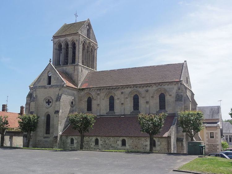
The Church of St. Martin has been listed as an historical monument since 1919 . It is a Romanesque church of the 12th century. The tower is protected by a gable roof (two-sided) of the 13th century.
The location was part of a World War I battlefield and there are many military cemeteries in the area. The German army held the high ground to the north known as the Chemin des Dames and resisted attacks by the French army to dislodge them in 1914, 1917 and 1918.
Geography
The village is located on the Aisne river and at the confluence of two canals, the Canal latéral à l'Aisne and the Canal de l'Oise à l'Aisne. It sits near the border of the regions of Picardy to the north west and Champagne-Ardenne to the south east. The Aisne drains into the basin of the river Seine and therefore Bourg-et-Comin is part of the Paris Basin. It has an Oceanic climate. The alluvial Aisne valley makes the landscape rich in lakes.
Population
Residents are known as Bourcominois.