
Type Boundary and economic | ||
 | ||
Signed October 8, 1866 (1866-10-08) Negotiators Chile:Aniceto Vergara AlbanoBolivia:Mariano Donato Muñoz Signatories Chile:Álvaro Covarrúbias.Bolivia:Juan R. Muñoz Cabrera | ||
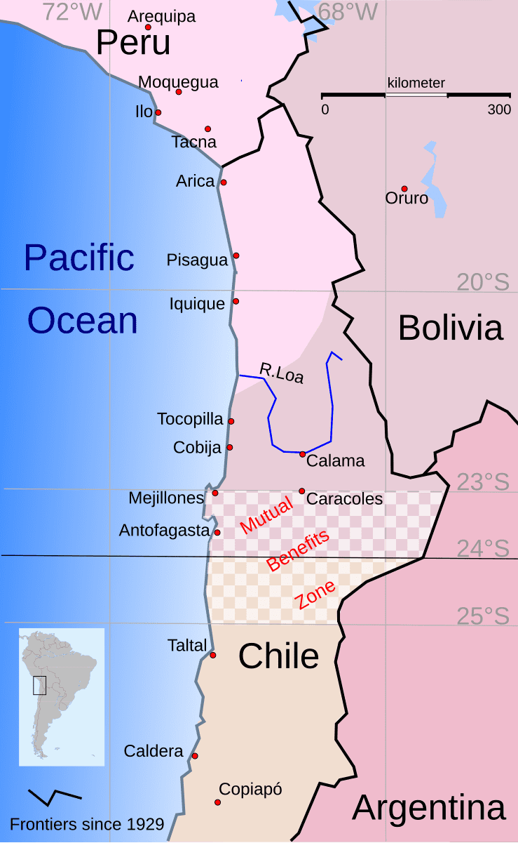
The Boundary Treaty of 1866 between Chile and Bolivia, also called the Mutual Benefits Treaty, was signed in Santiago de Chile on August 10, 1866 by the Chilean Foreign Affairs Minister Alvaro Covarrubias and the Bolivian Plenipotentiary in Santiago Juan R. Muñoz Cabrera. It drew, for the first time, the border between both countries at the 24° South parallel from the Pacific Ocean to the eastern border of Chile and defined a zone of bipartite tax collection, the "Mutual Benefits zone", and tax preferences for articles from Bolivia and Chile.
Contents
Despite increasing border tensions since the 1840s, both countries fought together against Spain in the Chincha Islands War (1864–65) and resolved the question under the Governments of Mariano Melgarejo in Bolivia and José Joaquín Pérez in Chile. But before long, both countries were discontented with it, and Peru and Bolivia signed a secret treaty against Chile in 1873. The Lindsay-Corral protocol, thought to clarify the treaty, was approved by Chile but never by Bolivia.
In 1874, a new boundary treaty was signed, which was violated by Bolivia in 1878. In 1879 began the War of the Pacific.
Background
After the independence wars, the new Latin American republics adopted as a common juridical principle of frontier demarcation the administrative limits existing at the moment of separation from Spain. This was termed in Uti possidetis of 1810, a formula devised mainly to prevent European nations from setting foot in America, on the plea that between one heritage and another there were vacant regions susceptible of being title of res nullius.
In particular, remote regions, sparsely populated or uninhabited areas, inhospitable climate, and sparse local vegetation caused a lack of geographical knowledge and hence administrative determination of the borders. But political unrest also led to changes, like the province of Tarija in colonial Argentina, which after independence wanted to come under Bolivian administration. On the other hand, European powers and the USA never recognized the principle of Uti possidetis 1810, as for example in the Falkland Islands. Since uncertainty characterized the demarcation of frontiers according to the Uti possidetis 1810, several long-running border conflicts arose in America after independence throughout the 19th century.
Bolivia had claimed territories down to latitude 26° South since its independence. In 1842, the Chilean Government of Manuel Bulnes declared the 23° South Parallel of latitude (near Mejillones) as the northern frontier of Chile, although at that time it was not possible to foresee the enormous importance of guano and nitrate.
From that day on, conflicts of jurisdiction between Chilean and Bolivian authorities were frequent. The Chilean ship Rumenia was carried to Cobija, the Bolivian port, and the Bolivian Sportsman to Caldera, Chile. Between 1842 and 1862, there were unsuccessful attempts at conciliation by both governments.
This situation could not continue indefinitely. Every day the affair was becoming more acute, because more interest was being taken in guano due to the increase in the revenue of Peru due to the deposits on the Chincha islands. The controversy became critical on 5 June 1863 as the Bolivian Congress secretly empowered the Executive to declare war on Chile.
An unexpected situation arose that modified the political relations of the nations of the Pacific: the war declared by Spain on Peru and Spain's reassertion of her claims to the Chincha islands. The Governments of the Pacific were alarmed, and Chile, Bolivia and Ecuador made common cause with Peru. Previous differences were considered as being of secondary importance, and Bolivia and Chile sought to end the border conflict. Interrupted diplomatic relations were resumed, and on 10 August 1866 the Boundary Treaty was signed in Santiago.
Content of the Treaty
The Treaty stipulated in seven articles:
Flaws of the Treaty
Regarding the Treaty of Mutual Benefits, Ronald Bruce St John states:
Differing interpretations of the 1866 treaty soon complicated diplomatic relations between Bolivia and Chile. The agreement did not specify by name the individual items from which Chile was to derive half the fiscal revenues under the condominium provision, and the Bolivian government tried to limit their number with predictably caustic results. In an apparent effort to avoid sharing customs receipts, the Bolivian government also sought to export minerals extracted from the shared zone through the northern port of Cobija. A related controversy centred on a Bolivian contention that Caracoles, an immensely valuable silver deposit discovered in 1870, did not lie within the zone of condominium. With the ousting of the Melgarejo administration in 1871, the new Bolivian government hoped to revise the terms of the 1866 treaty and thus abolish the condominium aspects of the pact. When this was not forthcoming the Bolivian National Assembly declared null and void all acts of the Melgarejo administration and made it clear that the 1866 treaty was in jeopardy.As a matter of fact, the Treaty settled nothing, it left everything pending and opened the door to difficulties greater than those it attempted to settle.
The Lindsay-Corral Protocol of 1872
On 5 December 1872, after difficult talks, Bolivian and Chilean negotiators Corral and Lindsay agreed to a clarification of the treaty of 1866. The Lindsay-Corral Protocol gave Chile the right to appoint customs officers to work alongside their Bolivian counterparts in the condominium zone, stipulated that tax rates could not be modified unilaterally, confirmed Bolivian acceptance of nitrates and borax as products included in the terms of the 1866 treaty, agreed that Bolivia would make a separate account of the amount to be received for taxes not derived from the common zone, and stated that the eastern limits of the common zone would be fixed by experts of both countries, and in case of disagreement, by a third nominated by the Emperor of Brazil. This Protocol was approved by Chile in January 1873.
A new grievance arose in August 1872 as Quintin Quevedo, a Bolivian diplomat, follower of Mariano Melgarejo who had been toppled as president in 1871, embarked on an expedition from Valparaiso against the Bolivian government, without any effective action of the Chilean authority, despite a warning by the Peruvian and Bolivian consulates about weapons and men on board the ships Maria Luisa and Paquete de Los Vilos.
Peru, which at that time enjoyed naval supremacy in South Pacific, responded with a naval demonstration in Mejillones, sending there the Huascar and the Chalaco. Peru's Minister of Foreign Affairs, Jose de la Riva Agüero, told the Chilean Government that Peru would not view with indifference the occupation of Bolivian territory by foreign forces.
In October 1872 the Bolivian Assembly authorized the executive to sign a treaty of alliance with Peru (without the necessity for further legislative consultation) which finally became the Secret treaty of alliance between Peru and Bolivia of 1873, signed on February 6, 1873, in Lima.
The Peruvian government saw the Lindsay-Corral Protocol as an increase in the regional influence of Chile and urged Bolivia to reject it, and in fact on May 19, 1873 the Bolivian Assembly postponed approval to 1874. The Assembly never approved nor refused the treaty.
In 1874, representatives of Bolivia and Chile reopened talks which concluded with the Treaty of Sucre or Boundary Treaty between Bolivia and Chile of 1874 (see English version in Boundary Treaty between Bolivia and Chile of 1874). The pact kept the 24th parallel as the boundary between Bolivia and Chile and Chile relinquished its former rights of condominium in return for no future nitrate tax increases over Chilean companies.