
Topo map USGS Boundary Peak Easiest route Scramble, class 2 Prominence 77 m | Elevation 4,007 m | |
 | ||
Listing U.S. state high point 9thNevada county high points 1stDesert Peaks Section Similar Montgomery Peak, White Mountain Peak, White Butte, Humphreys Peak, Wheeler Peak | ||
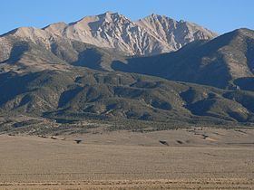
Boundary Peak is the highest point, at 13,147 feet (4,007 m), in the state of Nevada. It is the northernmost peak of the White Mountains, located in Great Basin region of the Western United States.
Contents
Map of Boundary Peak, Nevada 89010, USA
GeographyEdit
The summit is located in Esmeralda County of southwestern Nevada, and is within the Boundary Peak Wilderness of the Inyo National Forest.
While it is the highest point in Nevada, it is only about half a mile (1 km) from the California state line, and the considerably taller Montgomery Peak (13,441 feet (4,097 m)) located just across the state line in California. By most definitions Boundary Peak is considered to be a sub-peak of Montgomery Peak.
Boundary Peak is 82 feet (25 m) taller than Wheeler Peak located in Great Basin National Park, which by most definitions is the tallest independent mountain within the state.
ClimbingEdit
This peak is most often climbed from the Nevada side. From there, a climber may scramble the ridge connecting to Montgomery Peak. It is recommended that the U.S. Forest Service (Inyo National Forest) be contacted so they can provide climbing information.