
Status In use Type of dam Concrete gravity | Opening date 1840 Height 3 m | |
 | ||
Purpose Navigation, Water Supply Similar Huguenot Memorial Bridge, James River Park System, James River and Kanawha, New Pump‑House, Mayo Bridge | ||
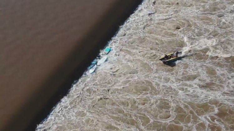
Bosher Dam is a historic but unnatural feature in the James River just west of Richmond, Virginia. A lowhead dam, also called a weir, is what paddlers ruefully call a "drowning machine," this 12-foot-high stone structure interrupts the natural flow of Virginia's largest self-contained river by spanning the waterway between suburban Tuckahoe in Henrico County and the western part of Richmond just west of the Edward E. Willey Bridge.
Contents
- Map of Bosher Dam Richmond VA 23235 USA
- People confirmed missing after group goes over Boshers Dam on James River in Richmond
- History
- Recent developments
- FutureEdit
- Incidents at BosherEdit
- References
Map of Bosher Dam, Richmond, VA 23235, USA
People confirmed missing after group goes over Bosher's Dam on James River in Richmond
History
The structure dates to 1835 at the location of an earlier dam designed to catch fish between slats. The current iteration was part of construction of the James River and Kanawha Canal, a major 19th Century transportation project whose emphasis in 1835 was getting boat traffic around the Falls of the James, the boulder-strewn whitewater that blocked river transport for at least ten miles around Richmond. The dam may have provided power for nearby gristmills and provided sufficient water depth to the Canal flowing on what eventually became a 22-mile pathway as it weaves above the north shore of the James around the Falls.
Recent developments
In recent years, hundreds of lowhead dams have been removed from American rivers in an effort to restore the traditional spawning grounds of native fish with notable nearby dam removals occurring in Charlottesville and in Fredericksburg.
Such fish as shad, herring, and striped bass—which make their migratory spawning runs between March and early June—had been blocked by Bosher, which made migration impossible for at least 300 miles upstream in the James, the Rivanna River, and other tributaries. While the dam still functions to get water into the Canal, which has become more of a historic feature than a means of transportation, it has also created conditions to make this section of the James suitable for powerboating with waterskiing and other activities typically available only on lakes and larger waterways. Perhaps the rise of powerboating explains why, rather than breach or demolish the dam, as has been the recent custom in other communities, the Virginia Department of Game and Inland Fisheries decided instead to build an extensive fish ladder aside the dam. Opened in 1999, the fish ladder allows the migratory fish around the dam via a 17-inch-wide pathway.
FutureEdit
With the 10 acres north of the dam belonging to the James River Park System, an opportunity exists to create more public access to this scenic area. Whether such parties as the neighbors along upscale Cherokee Road and Riverside Drive, as well as the Virginia Power Boat Association [1] will smile on such an effort remains unknown. The dam will be retrofitted with a turbine to generate electricity ?" The proposed project would consist of: the existing 12-foot-high dam; a 1,000-acre impoundment with a storage capacity of 2,100 acre-feet and drainage area of 6,753 square miles; a new 700-foot-long, 180-foot-wide intake; a new 300-foot-long, 180-foot-wide tailrace; four new 2-MW turbines; a new 65-foot-long, 197-foot-wide powerhouse; a new 60-foot-long, 50-foot-wide substation; and a new 528-foot-long, 69-kV transmission line. The estimated annual generation of the project would be 68,500 MWh.
One Richmond-area news source has posed the question: "Should a park be created at Bosher’s Dam?"
Incidents at BosherEdit
Because lowhead dams can be nearly invisible to people on boats, giving an impression similar to the edge of an infinity pool, boaters can encounter them inadvertently. Lowhead dams can be particularly hazardous because they tend to create "hydraulics," currents that push objects (and people) underwater [2] and then inextricably cycle them for hours, days, or weeks until the water level changes.