
Founded 1837 Area 730.4 km² | Website www.boonecountyil.org Population 53,957 (2013) Unemployment rate 5.3% (Apr 2015) | |
 | ||
Points of interest Pettit Memorial Chapel, Spencer Park, Summerfield Zoo, Vintage Wings & Wheels M, Lions Park | ||
Boone County is a county located in the U.S. state of Illinois. As of the 2010 census, the population was 54,165. Its county seat is Belvidere.
Contents
- Map of Boone County IL USA
- History
- Geography
- Adjacent counties
- Major highways
- Climate and weather
- Demographics
- Education
- Cities
- Villages
- Census designated places
- Townships
- References
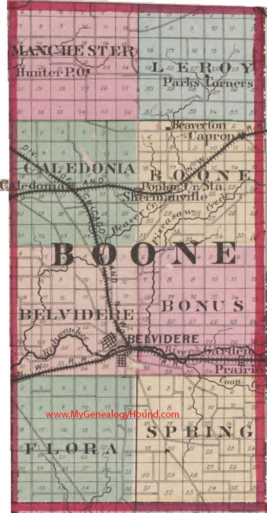
Map of Boone County, IL, USA
Boone County is included in the Rockford, IL Metropolitan Statistical Area, as well as the Chicago metropolitan area.
History
Boone County was formed in 1837 out of Winnebago County. It was named for Kentucky frontiersman Daniel Boone. The first non-Native American settlers arrived in what is now Boone County in 1835. They arrived as a result of the end of the Black Hawk War as well as the completion of the Erie Canal. They consisted entirely of settlers from New England. These were "Yankee" settlers, that is to say they were descended from the English Puritans who settled New England in the colonial era. They were primarily members of the Congregational Church though due to the Second Great Awakening many of them had converted to Methodism and some had become Baptists before coming to what is now Boone County. When the New England settlers arrived in what is now Boone County there was nothing but a dense virgin forest and wild prairie. In the late 1870s immigrants began arriving from Germany and Ireland.
Geography
According to the U.S. Census Bureau, the county has a total area of 282 square miles (730 km2), of which 281 square miles (730 km2) is land and 1.3 square miles (3.4 km2) (0.5%) is water.
Adjacent counties
Major highways
Logan Avenue county route 40 Genoa Road (T-40) Garden Prairie Road county route 41 Poplar Grove Road county route 32 Capron Road (T-41)
Climate and weather
In recent years, average temperatures in the county seat of Belvidere have ranged from a low of 11 °F (−12 °C) in January to a high of 85 °F (29 °C) in July, although a record low of −29 °F (−34 °C) was recorded in January 1979 and a record high of 109 °F (43 °C) was recorded in July 1936. Average monthly precipitation ranged from 1.29 inches (33 mm) in February to 4.56 inches (116 mm) in June.
Demographics
As of the 2010 United States Census, there were 54,165 people, 18,505 households, and 14,273 families residing in the county. The population density was 193.0 inhabitants per square mile (74.5/km2). There were 19,970 housing units at an average density of 71.1 per square mile (27.5/km2). The racial makeup of the county was 84.4% white, 2.0% black or African American, 1.3% Asian, 0.4% American Indian, 9.3% from other races, and 2.6% from two or more races. Those of Hispanic or Latino origin made up 20.2% of the population. In terms of ancestry, 25.6% were German, 13.7% were Irish, 9.2% were English, 8.6% were American, 7.7% were Italian, 7.1% were Swedish, and 5.0% were Polish.
Of the 18,505 households, 41.5% had children under the age of 18 living with them, 61.6% were married couples living together, 10.2% had a female householder with no husband present, 22.9% were non-families, and 18.9% of all households were made up of individuals. The average household size was 2.91 and the average family size was 3.32. The median age was 36.8 years.
The median income for a household in the county was $61,210 and the median income for a family was $69,380. Males had a median income of $53,581 versus $34,651 for females. The per capita income for the county was $26,105. About 7.9% of families and 10.4% of the population were below the poverty line, including 15.3% of those under age 18 and 5.0% of those age 65 or over.
Education
Cities
Villages
Census-designated places
Townships
Boone County is divided into these nine townships: