
Population 327 (2011) Community Bodfari Sovereign state United Kingdom Local time Sunday 11:37 PM | OS grid reference SJ093701 Country Wales Postcode district LL16 Dialling code 01745 | |
 | ||
Weather 6°C, Wind W at 16 km/h, 90% Humidity | ||
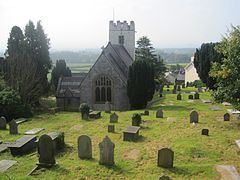
Bodfari is a village in Denbighshire, Wales. Until the local government reorganisation of 1974, Bodfari was in the historic county of Flintshire.
Contents
Map of Bodfari, UK
The ancient parish of Bodfari comprised the townships of Bodfari, which was in historic Flintshire, and Aberwheeler, in historic Denbighshire.
Location
Bodfari is located at the approximate grid reference SJ093701. The village lies on the A541 road at the point where the road passes through a gap in the Clwydian Hills, the gap being part of the valley of the River Wheeler (Welsh: Afon Chwiler).
The Offa's Dyke National Trail passes through the village, and for walkers completing the trail south to north, Bodfari is usually the final overnight stop on the 177 mile route.
References
Bodfari Wikipedia(Text) CC BY-SA