
Local time Sunday 7:05 PM | Population 9,314 (2012) | |
 | ||
Weather 30°C, Wind SE at 5 km/h, 59% Humidity | ||
Boali is a town located in the Central African Republic prefecture of Ombella-M'Poko.
Map of Boali, Central African Republic
Boali is located on National Highway 1 (RN1), about 100 km northwest of the national capital, Bangui. The road, one of the country's few paved highways, leads on to Bouar, and ultimately to Cameroon.
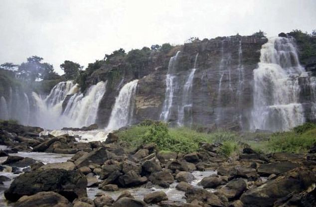
Situated on the Mbali River, Boali is noted for its waterfalls and for the nearby hydroelectric works. The Falls of Boali are 250 m wide and 50 m high, and are a popular tourist destination.
The hydroelectric works, Boali I and Boali II, are located below the falls. They have a combined generating power of 18.65 megawatts, and are operated by the state-run Central African Energy (ENERCA). The completion of Boali I in the 1950s spurred several other industrial developments in the town, including the country's first textile mill, which began operating in 1954.
The Boali hydroelectric works supply power to the capital and 13 other towns. This strategic role was used by the Seleka rebels in March 2013, who took over the plant on their way to Bangui and shut off power to the city.
Initial arrangements were made in 2010 for a third hydroelectric plant, Boali 3, to be built with Chinese assistance.