
 | ||
Similar Jin Island, Town Island, Chek Chau, Sharp Island, Kau Sai Chau | ||
Bluff island inc coral hong kong
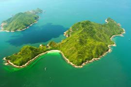
Bluff Island, indigenously known as Sha Tong Hau Shan (Chinese: 沙塘口山), also known as Ung Kong (甕缸), is an island in Port Shelter, south of Sai Kung Peninsula of Hong Kong. It is an important area for corals and other marine life. The island is zoned as Site of Special Scientific Interest since 1979. The surrounding water has not yet been legally protected and thus the corals are damaged by anchors of holiday visitors.
Contents
- Bluff island inc coral hong kong
- Map of Bluff Island Hong Kong
- Bluff island hong kong drone video
- Geography
- References
Map of Bluff Island, Hong Kong
Together with Basalt Island and Wang Chau, it forms the Ung Kong Group (甕缸群島) and is part of Hong Kong National Geopark.
Bluff island hong kong drone video
Geography
The elongate Bluff Island, which is oriented northeast to southwest, reaches a maximum elevation of a little over 140 meters. The island is asymmetrical, forming a high ridge on the south-eastern side with a cliffed coastline. In contrast, the north-western aspect of the island slopes more gently towards a rocky coastline. The 140-meter high cliffs that fringe the south-eastern-facing coast of Bluff Island are the highest sea cliffs in Hong Kong.
Fan Tap Pai (番塔排) in the south of the Island is one of the most spectacular coastal scenes in Hong Kong. This huge sea cave cuts right through the island and it is just wide enough for a boat to sail past.
An open U-shaped bay, Ung Kong Wan (甕缸灣), is located at the north of the island.