
Area 6.7 km² | ||
 | ||
Similar Sharp Island, Jockey Club Kau Sai Chau, Green Island - Hong Kong, Tung Lung Chau, Hei Ling Chau | ||
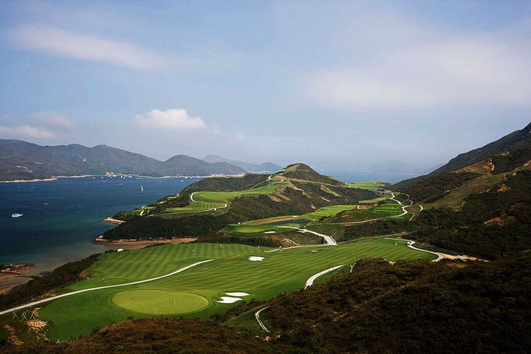
Yuneec q500 aerial shot of kau sai chau golf course 13 14 15 hold
Kau Sai Chau (Chinese: 滘西洲) is an island located off the coast of Sai Kung of Hong Kong, with an area of 6.70 km², making it the 6th largest island of Hong Kong. It is under the administration of Sai Kung District.
Contents
- Yuneec q500 aerial shot of kau sai chau golf course 13 14 15 hold
- Map of Kau Sai Chau Hong Kong
- Hkuhgroup verbal history of kau sai chau
- Geography
- Features
- Transportation
- References
Map of Kau Sai Chau, Hong Kong
Hkuhgroup verbal history of kau sai chau
Geography
Kau Sai Chau is located south of the Sai Kung Peninsula. Its northern shore forms part of the southern limit of Port Shelter, of which it is the largest island. Kau Sai Chau is connected in the north by a breakwater to the smaller island Yim Tin Tsai. The southern tip of the island is separated by a narrow channel from Jin Island. It has a maximum elevation of 216 m.
Features
The Jockey Club Kau Sai Chau Public Golf Course, developed and run by the Hong Kong Jockey Club, is the only public golf course in Hong Kong. Opened in 1995, it occupies approximately the northern half of the island. It comprises three 18-hole golf courses: the North and South Courses were designed by Gary Player, while Nelson & Haworth designed the East Course.
Kau Sai Village is a small fishing hamlet with about ten houses. It is located at the southern tip of the island.
Two declared monuments of Hong Kong are located on Kau Sai Chau: a prehistoric rock carving and a Hung Shing Temple:
The prehistoric rock carving was discovered in 1976. It is located on the north-western coast of the island, in a location "where accessibility by land is extremely poor".
The Hung Shing Temple is located in the southern part of the island, near Kau Sai Village, of which it is the only temple. The building was built before 1889. It is constructed in grey bricks with a timber roof frame. The temple has been renovated four times, in 1949, in the 1970s, in 1988 and the last being from August 1999 to February 2000. The restoration was declared an "Outstanding Project" by the UNESCO Asia-Pacific Heritage 2000 Awards. Previously a Grade III Historic Building, the temple was declared a monument on November 15, 2002. The Hung Shing Festival (洪聖誕) is celebrated there on the 13th day of the 2nd month in Chinese calendar.
There are wild boars wandering the island. They come out typically at night and cause serious damage to the golf course.
Transportation
A scheduled ferry service connects Sai Kung Town and the ferry pier of the Public Golf Course. Other parts of the island may be reached by privately owned boats from Sai Kung Pier. The Hong Kong Jockey Club runs three Solar Sailor ferries to the island per hour. Also, Kau Sai Village may be reached by an approximately 40 minute walk along the Water Services supply line (for safety reasons, walking onto the golf courses is not advised).