
 | ||
Blocks in meteorology are large-scale patterns in the atmospheric pressure field that are nearly stationary, effectively “blocking” or redirecting migratory cyclones. They are also known as blocking highs or blocking anticyclones. These blocks can remain in place for several days or even weeks, causing the areas affected by them to have the same kind of weather for an extended period of time (e.g. precipitation for some areas, clear skies for others). In the Northern Hemisphere, extended blocking occurs most frequently in the spring over the eastern Pacific and Atlantic Oceans.
Contents
Impact of the polar vortex
Polar cyclones are climatological features which hover near the poles year-round. They are weaker during summer and strongest during winter. When the polar vortex is strong, the Westerlies increase in strength. When the polar cyclone is weak, the general flow pattern across mid-latitudes buckles and significant cold outbreaks occur. Extratropical cyclones which occlude and migrate into higher latitudes create cold-core lows within the polar vortex. Volcanic eruptions in the tropics lead to a stronger polar vortex during the winter for as long as two years afterwards. The strength and position of the cyclone shapes the flow pattern across the hemisphere of its influence. An index which is used in the northern hemisphere to gage its magnitude is the Arctic oscillation.
Omega blocks
Omega blocks are so-named because the height fields with which they are associated in the Northern Hemisphere resemble an Ω, the uppercase Greek letter omega. They typically have a low-high-low pattern, arranged in the west–east direction.
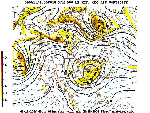
Rex blocks
Rex blocks (or dipole blocks) consist of a high situated to the north (more generally, poleward) of a low. Very often both the high and the low are closed, meaning that the isobars (or constant geopotential height lines) defining the high–low close to form a circle. Rex blocks are named after the meteorologist who first identified them.
Cut-off highs and lows
When an upper-level high- or low-pressure system becomes stuck in place due to a lack of steering currents, it is known as being "cut off". The usual pattern which leads to this is the jet stream retreating poleward, leaving the then cut-off system behind. Whether or not the system is of high- or low-pressure variety dictates the weather that the block causes. Precisely this situation occurred over the southern United States during late spring and early summer of 2007, when a cut-off-low system hovering over the region brought unusually cool temperatures and an extraordinary amount of rain to Texas and Oklahoma (see June 2007 Texas flooding), and a cut-off-high near the coast of Georgia that caused a drought in the Southeast that same year.
If the block is a high, it will usually lead to dry, warm weather as the air beneath it is compressed and warmed, as happened in southeastern Australia in 2006 and 1967 with resultant extreme droughts. Rainy, cooler weather results if the block is a low.
Cold air damming
Blocking of atmospheric systems near the surface of the Earth occurs when a well-established poleward high pressure system lies near or within the path of the advancing storm system. The thicker the cold air mass is, the more effectively it can block an invading milder air mass. The depth of the cold air mass is normally shallower than the mountain barrier which created the cold air damming, or CAD. Some events across the Intermountain West can last for ten days. Pollutants and smoke can remain suspended within the stable air mass of a cold air dam.
Midlatitude cold waves
In the middle latitudes of the Northern Hemisphere, areas on the eastern side of blocking anticyclones or under the influence of anomalous flows from colder continental interiors related to blocks experience severe winters, a phenomenon which has been known since the discovery of the North Atlantic Oscillation in the 1840s. These blocking patterns also have a tendency to produce anomalously mild conditions at very high latitudes, at least in those regions exposed to anomalous flow from the ocean as in Greenland and Beringia, or from chinook winds as in Interior Alaska.
Such cold winters over the contiguous United States and southern Canada as 1911/12, 1935/36, 1977/78 and 1978/79 resulted from blocks in the Gulf of Alaska or to the east of the Mackenzie Mountains directing very cold Arctic air with a long trajectory as far as the American South, as did the Western cold waves of 1889/90 and January 1950. In Northern and Western Europe, cold winters such as 1683/84, 1739/40, 1794/95, 1829/30, 1894/95, 1916/17, 1941/42, February 1947 and 1962/63 are almost always associated with high-latitude Atlantic blocking and a poleward shift of the jet stream to Portugal and even Morocco. Over Central Asia, unusually cold winters like 1899/1900, 1929/30 and 1930/31, 1944/45, 1954/55 and 1968/69 are associated with blocking near the Ural Mountains extending the Siberian High westwards to push the very cold air from the Siberian “cold pole” outward towards the Aral and Caspian Seas. Unlike other midlatitude regions of the Northern Hemisphere, however, cold winters in Europe (e.g. 1916/17, 1962/63) are often very mild over Central Asia, which can gain warm air advection from subtropical cyclones pushed to the south under negative NAO conditions.