
Population 7,330 (2013 est) Blayney Shire Bathurst | Mayor Scott Ferguson Area 1,525 km² | |
 | ||
27 02 17 dr keith suter blayney shire council
Blayney Shire is a local government area in the Central West region of New South Wales, Australia. The Shire is located adjacent to the Mid-Western Highway and the Main Western railway line, and is centred on the town of Blayney.
Contents
- 27 02 17 dr keith suter blayney shire council
- Map of Blayney NSW Australia
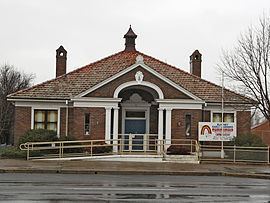
- Blayney shire council
- Towns and localities
- Current composition and election method
- Proposed amalgamation
- References
Map of Blayney, NSW, Australia
Blayney Shire consists of approximately 1,600 square kilometres (620 sq mi) of well watered, gently undulating to hilly country and the climate is partially suitable for cool climate crops and trees. There is also significant mining industry in the shire.
Blayney shire council
Towns and localities
Towns and locaties within the Blayney Shire are:
Current composition and election method
Blayney Shire Council is composed of seven Councillors elected proportionally as a single ward. All Councillors are elected for a fixed four-year term of office. The Mayor is elected by the Councillors at the first meeting of the Council. The most recent election was held on 8 September 2012, and the makeup of the Council is as follows:
The current Council, elected in 2012, in order of election, is:
Proposed amalgamation
A 2015 review of local government boundaries recommended that the Blayney Shire merge with the Cabonne Shire and the City of Orange to form a new council with an area of 7,833 square kilometres (3,024 sq mi) and support a population of approximately 63,000. The outcome of the independent review is expected to be completed by mid–2016.