
OS grid SD977163 | Elevation 472 m | |
 | ||
Similar Pennines, Windy Hill, Black Hill, Bleaklow, Boulsworth Hill | ||
Hiking england pennine way part 4 blackstone edge to hebden dale
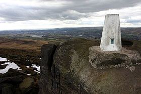
Blackstone Edge is a gritstone escarpment at 1,549 feet (472 m) above sea level in the Pennine hills surrounded by moorland on the boundary between Greater Manchester and West Yorkshire in England.
Contents
- Hiking england pennine way part 4 blackstone edge to hebden dale
- Map of Blackstone Edge Ripponden Sowerby Bridge UK
- Blackstone edge rishworth moor rochdale manchester
- HistoryEdit
- SportEdit
- References
Map of Blackstone Edge, Ripponden, Sowerby Bridge, UK
Blackstone edge rishworth moor rochdale manchester
HistoryEdit
Passing by the crag is Blackstone Edge Long Causeway also known as Blackstone Edge Roman Road, a paved road originally thought to be of Roman origin but after investigations by James Maxim considered to be a 1735 turnpike or packhorse route. The Aiggin Stone, a gritstone pillar, possibly a way-marker stands alongside the packhorse route marking the county boundary. The stone has a cross and the letters I and T cut into it. Its name is said to derive from the French aiguille for a needle or aigle an eagle.
Much of the surrounding area was within the ancient parish of Hundersfield, although some parts lay within Butterworth township. In the English Civil War the Parliamentarians sent 800 men to fortify Blackstone Edge where John Rosworm came from Manchester to direct the construction of defences. It was successfully held against an attack by Royalist cavalry. In 1660 the churchwardens of St Chad's paid 24 shillings for eight loads of "great stones from Blackstoneedge" for Rochdale church steps. Celia Fiennes travelled over Blackstone Edge and described her journey in about 1700. A meeting of supporters of Chartism from the surrounding industrial towns of Lancashire and Yorkshire was held in 1846 attracting up to 30,000 people.
SportEdit
Blackstone Edge is frequented by walkers and rock climbers who use its traditional climbing and bouldering routes. The crag was featured in the 1913 rock climbing guide to the Peak District, 'Some Gritstone Climbs' by John Laycock. One walking route is a circular walk from Hollingworth Lake in Smithy Bridge near Littleborough up to Blackstone Edge and another route links Blackstone Edge to Hebden Bridge in the Calder Valley. The Pennine Way long-distance footpath from Edale in the Derbyshire Peak District to Kirk Yetholm in Scotland passes along the top of the outcrop. It is also an optional route of the Rochdale Way. From the summit it is possible to see Manchester city centre, Winter Hill in the West Pennine Moors and the mountains in North Wales in clear weather.