
Topo map USGS Freehold, NY Prominence 628 m | Elevation 1,213 m Mountain range Catskill Mountains | |
 | ||
Similar Blackhead, Windham High Peak, Thomas Cole Mountain, Kaaterskill High Peak, Indian Head Mountain | ||
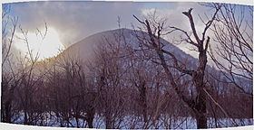
Black Dome is a mountain located in Greene County, New York. The mountain is the highest peak of the Blackhead Mountains range of the Catskills. Black Dome is flanked to the east by Blackhead, and to the west by Thomas Cole Mountain.
Map of Black Dome, Jewett, NY 12424, USA
Black Dome stands within the watershed of Schoharie Creek, which drains into the Mohawk River, the Hudson River, and into New York Bay. The south side of Black Dome drains into East Kill, and thence into Schoharie Creek. The north side of Black Dome drains into Batavia Kill, and thence into Schoharie Creek.
Black Dome is within New York's Catskill Park.
References
Black Dome (New York) Wikipedia(Text) CC BY-SA