
Parent range Cascades Elevation 1,938 m | Last eruption About 9,500 years ago Range Cascade Range | |
 | ||
Similar Shastina, Mount Eddy, Castle Crags, Castle Lake, Cascade Range | ||
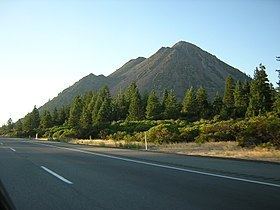
Black Butte is a cluster of overlapping dacite lava domes in a butte, a parasitic satellite cone of Mount Shasta. It is located directly adjacent to Interstate 5 at milepost 742 between the city of Mount Shasta and Weed, California. The highway crosses a 3,912 ft (1,192 m) pass, Black Butte Summit, at the western base of the lava domes. The lava domes were extruded at the foot of the cone of Shastina following the period of its major eruptions about 9,000–10,000 years ago.
Map of Black Butte, California 96067, USA
A United States Forest Service fire lookout tower was built on the summit in the 1930s, but destroyed during the Columbus Day Storm of 1962. A new lookout was built in 1963 and operated until 1973. The building was moved by helicopter to a new location in 1975 and only the concrete foundation remains today. A 2.5-mile (4.0 km) long trail leads to the summit from a trailhead accessible by dirt roads off the Everitt Memorial Highway. The summit boasts an outstanding view of the southwest side of Shasta and Shastina, and on clear days Mount McLoughlin is easily visible 70 miles (113 km) to the north in Oregon.