
Easiest route Hiking | Elevation 940 m | |
 | ||
Similar Brennisteinsalda, Torfajökull, Rauðhólar, Eldgjá, Tindfjallajökull | ||
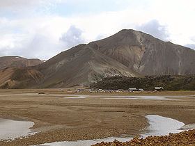
Bláhnjúkur is a volcano in the south of Iceland. Its height is 940 m.
Map of Bl%C3%A1hnj%C3%BAkur, Iceland
Its name translates to blue peak in English. This comes from the blue-black colour of its sides. The colour is due to volcanic ash and lava flows.
The mountain is situated in Landmannalaugar, a natural park near Hekla. It lies next to the volcano Brennisteinsalda.
A hiking trail leads up to the top of the mountain from which, in good conditions, five glaciers are visible.
The best way to get to the peak is on road number F 208. The hike is considered easy and takes 1-2 hours round-trip.
References
Bláhnjúkur Wikipedia(Text) CC BY-SA