
Country Guinea-Bissau ISO 3166 code GW-BS Local time Thursday 8:59 PM | Founded 1687 Elevation 0 cm Population 387,909 (2009) | |
 | ||
Region Bissau Autonomous Sector Weather 27°C, Wind SW at 11 km/h, 72% Humidity University Universidade Colinas de Boé | ||
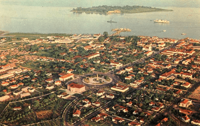
Bissau is the capital city of Guinea-Bissau. In 2007 Bissau had an estimated population of 407,424. Bissau is located on the Geba River estuary, off the Atlantic Ocean, and is Guinea-Bissau's largest city, major port, and its administrative and military centre.
Contents
- Map of Bissau Guinea Bissau
- Discovering guinea bissau part i
- History
- Geography and climate
- Demographics
- Economy
- Education
- Landmarks
- Twin towns Sister cities
- References
Map of Bissau, Guinea-Bissau
Discovering guinea bissau part i
History
The city was founded in 1687 by Portugal as a fortified port and trading center. In 1942 it became the capital of Portuguese Guinea.
After the declaration of independence by the anti-colonial guerrillas of PAIGC in 1973, the capital of the de facto independent territories was declared to be Madina do Boe. Bissau remained as the capital of the Portuguese-occupied regions, and the de jure capital of all of Portuguese Guinea. When Portugal recognized the independence of Guinea-Bissau and decolonised in 1974 due to the military coup of April 25 in Lisbon, the two territories merged and Bissau became the capital of the new independent state. The city is known for its annual carnival.
The city, as the seat of government, was the scene of intense fighting during the beginning and end of the Guinea-Bissau Civil War in 1998 and 1999.
Geography and climate
Bissau is located at 11°52' North, 15°36' West (11.86667, -15.60) [1], on the Geba River estuary, off the Atlantic Ocean. The land surrounding Bissau is extremely low-lying, and the river is accessible to ocean-going vessels despite its modest discharge for about 80 kilometres (50 mi) beyond the city.
Bissau has a tropical savanna climate (Köppen Aw), not quite wet enough to qualify as a tropical monsoon climate (Am) but much wetter than most climates of its type. Almost no rain falls from November to May, but during the remaining five months of the year the city receives around 2,020 millimetres (80 in) of rain. During the wet season and even during the three months beforehand, high humidity makes heat discomfort extreme.
Demographics
The last time an official census was held in the country in 1991, Bissau had a population of 195,389. By 2007 Bissau had an estimated population of 407,424.
Economy
Bissau is the country's largest city, major port, educational, administrative and military center. Peanuts, hardwoods, copra, palm oil, and rubber are the chief products. The airport that serves Bissau is Osvaldo Vieira International Airport.
Education
There are two Portuguese international schools in Bissau:
Landmarks
Attractions include the Portuguese-built Fortaleza de São José da Amura barracks from the 18th century, containing Amílcar Cabral's mausoleum, the Pidjiguiti Memorial to the dockers killed in the Bissau Dockers' Strike on August 3, 1959, the Guinea-Bissau National Arts Institute, Bissau New Stadium and local beaches.
Many buildings in the city were ruined during the Guinea-Bissau Civil War (1998–1999), including the Guinea-Bissau Presidential Palace and the Bissau French Cultural Centre (now rebuilt), and the city centre is still underdeveloped.
Twin towns – Sister cities
Bissau is twinned with: