
Population 1,483. 2011 Census Civil parish Birdham Area 6.96 km² Dialling code 01243 | OS grid reference SU824003 Sovereign state United Kingdom Local time Thursday 8:36 AM | |
 | ||
Weather 7°C, Wind W at 34 km/h, 60% Humidity | ||
Birdham is a village and civil parish in the Chichester District of West Sussex, England. It is located on the Manhood Peninsula, about five miles (8 km) south west of the city of Chichester. The parish church is dedicated to St James although the dedication was to St. Leonard until c 1900.
Contents
Map of Birdham, UK
The nearest railway station is some three miles (5 km) northeast of the village, at Chichester or Fishbourne.
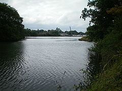
The village sits on the shores of Chichester Harbour and is home to a locked marina on the site of a former tide mill pond. The tide mill building itself still exists. In between it and Chichester marina are the lockgates to the disused Chichester Canal opened in 1822. The local school is Birdham C of E Primary School. According to the 2001 census it had a population of 1,408.
HMS Birdham, a minesweeper, launched on 19 September 1955, was named after the village.
History
The only evidence of prehistoric settlement is a Bronze Age settlement.
Birdham is first mentioned in a series of Anglo-Saxon charters relating to land grants to the See of Selsey. Unfortunately most of these are forgeries,