
- location Along coast | - elevation 2,955 m (9,695 ft) Area 55,604 km² | |
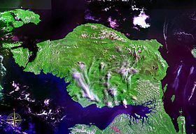 | ||
Raja ampat bird s head peninsular west papua january 2014
The Bird's Head Peninsula (Indonesian: Kepala Burung, Dutch: Vogelkop) or Doberai Peninsula is a large peninsula that makes up the northwest portion of the island of New Guinea and the major part of the Province of West Papua, Indonesia. (See also Bird's Tail Peninsula.)
Contents
- Raja ampat bird s head peninsular west papua january 2014
- Map of Jazirah Doberai Womba South Aifat Maybrat Regency West Papua Indonesia
- Location and geography
- Flora and fauna
- Culture
- References
Map of Jazirah Doberai, Womba, South Aifat, Maybrat Regency, West Papua, Indonesia
Location and geography
The Bird's Head Peninsula forms the northwestern end of the island of New Guinea. To the east is Cenderawasih Bay and to the south Bintuni Bay. To the west, across the Dampier Strait is Waigeo island of Raja Ampat, and Batanta island lies just off the northwest tip. The peninsula south is Bomberai Peninsula.
The peninsula is around 200 by 300 kilometers, and is bio-geographically diverse, containing coastal plains to the south. The Arfak Mountains are a 2900-meter-high mountain range that are found in the east. Slightly shorter than the Arfak Mountains, the Tamrau Mountains are found in the north. Bon Irau is the highest mountain in the Tamrau Mountains, at 2,501 meters (8,205 feet). The highest mountain on the Bird's Head Peninsula is Pegunungan Arfak. It is 2,955 meters (9,695 feet) high and is located 21 miles southwest of Manokwari. Both of the mountain ranges have a diverse mix of sandstone, limestone, and volcanic rock. A large basin called the Kebar Valley divides the two mountain ranges apart.
Flora and fauna
The peninsula is covered by the Vogelkop Montane Rain Forests Ecoregion. It includes more than 22,000 km2 of montane forests at elevations of 1,000 m and higher. Over 50% of these forests are located within protected areas. There are over 300 bird species on the peninsula, of which at least 20 are unique to the ecoregion, and some live only in very restricted areas. These include the grey-banded munia, Vogelkop bowerbird, and the king bird-of-paradise.
Road construction, illegal logging, commercial agricultural expansion and ranching potentially threaten the integrity of the ecoregion. The south-western coast of the Bird's Head Peninsula forms part of the Teluk Cenderawasih National Park.
Culture
Archaeological findings indicate that local settlement dates back at least 26,000 years BP. Today, most people live in villages along the coast, with small concentrations inland. Villagers practise subsistence farming by shifting cultivation of copra, rice, corn and peanuts, as well as hunting. There are more than 80 villages scattered around the peninsula. There are about 18 main settlements that are the principal town of one of the five regencies found on the peninsula. These cities include Bintuni, Teminabuan, Sorong, Aimas, and Manokwari. Although, the largest settlements are the city of Sorong on the west coast and Manokwari on the east coast. Manokwari is the largest city with as of 2010 a population of 135,000 and a metropolitan area of 155,000. The city of Sorong has a population of 125,000 and a metropolitan area of 170,000. This city also has the largest metropolitan area.
There are a large number of traditional languages spoken on the peninsula, classified as South Bird's Head languages, East Bird's Head languages, or West Papuan languages.