Fought September 2–3, 1862 Phone +1 800-657-3773 | NRHP Reference # 73000995 Area 33 ha Added to NRHP 4 June 1973 | |
 | ||
Address Co Hwy 2, Morton, MN 56270, USA Similar Minnesota History Center, Minnesota State Capitol, Lower Sioux Agency, Fort Ridgely, Forest History Center | ||
Birch coulee battlefield and park parks in minnesota
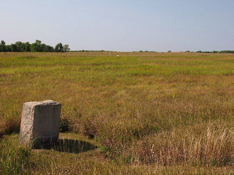
Birch Coulee Battlefield in Renville County, Minnesota, United States, was the site of the Battle of Birch Coulee, the costliest military engagement for U.S. forces during the Dakota War of 1862. It is now a historic site with self-guided trails and markers interpreting the battle from both sides. Birch Coulee was nominated to the National Register of Historic Places for having state-level significance in military history, and was listed in 1973.
Contents
- Birch coulee battlefield and park parks in minnesota
- Geography
- Battle of Birch Coulee
- Battlefield preservation
- References
Geography
Birch Coulee Battlefield lies on what, in 1862, was open prairie stretching on to the north and west, with woods to the south. Defining the east edge is a steep wooded ravine, a landform known locally by the French term "coulee," also spelled "coulie" or "cooley." Birch Coulee, known to the Dakota as Tanpa Yukan (Place of the White Birch), is 60 feet (18 m) deep and runs for a total of seven miles (11 km) down to the Minnesota River. A few hundred yards to the west of the coulee, the prairie rises slightly onto a gentle knoll.
Battle of Birch Coulee
On September 1, 1862, a burial detail of about 170 Union Army volunteers and civilians under Major Joseph R. Brown camped on the prairie west of Birch Coulee. The site was selected by Captain Hiram Grant earlier that day while Brown was ahead scouting. A group of Dakota soldiers under Zitkahtahhota (Gray Bird), on their way to attack New Ulm, chanced upon the U.S. soldiers camping in a tactically weak position. Hidden by the ravine and the tall prairie grass, the Dakota surrounded the camp and attacked at dawn, inflicting heavy casualties and killing most of the army's horses. With the Union party cut off from fresh water and dug in behind their dead mounts, the Dakota maintained a daylong siege, letting occasional gunfire and the hot sun take their toll.
16 miles (26 km) away at Fort Ridgely, a guard reported distant gunfire, and 240 men were dispatched to investigate. They came within sight of their besieged comrades, but Dakota soldiers hidden in the coulee under the leadership of Mankato began whooping and shouting. Frightened into thinking there were hundreds of Dakota lying in ambush, the relief party retreated. A larger relief party marched through the night under Colonel Henry Hastings Sibley. Seeing them, the Dakota slipped away, ending the 30-hour siege. The U.S. casualties in the battle were thirteen dead, almost fifty wounded, and ninety horses killed. Dakota leader Wamditanka (Big Eagle) later recorded only two men killed on his side.
Battlefield preservation
The first effort to officially preserve the Birch Coulee Battlefield came in 1893, when the Minnesota Legislature appointed a commission to acquire the land with a $2,500 budget and authority to use eminent domain. Inexplicably the commission chose instead to acquire a 1.75-acre (0.71 ha) property two miles (3.2 km) south of the battlefield, where they raised a 46-foot (14 m) granite monument. At the dedication ceremony on September 3, 1894, former governor William Rainey Marshall lambasted the commission in his speech.
The state legislature provided additional money in 1895, along with clear instructions to secure acreage on the actual battlefield, but no action was taken. It wasn't until 1929, following a resurgence of community advocacy, that the state acquired the site and proclaimed it the Birch Cooley Battle Field State Memorial Park. In 1937 a Works Progress Administration crew helped develop the park, reseeding the land and building amenities like trails, roads, picnic area, and a parking lot.
In 1976 legislative action redesignated the property a state historic site and transferred management to the Minnesota Historical Society. The Historical Society redeveloped the battlefield beginning in 1998 and it reopened to the public in 2000. Self-guided interpretive signs describe the battle from the perspectives of Captain Joseph Anderson and Wamditanka, illustrated with sketches by soldier Albert Colgrave. Guideposts mark the U.S. camp and the positions of the surrounding Dakota. Management has since been transferred to the Renville County Parks Department, which also maintains a campground on site.
