
Country Norway District Helgeland Area rank 76 in Norway Area 1,264 km² Local time Thursday 3:36 AM Official language form Bokmål | County Nordland Administrative centre Terråk Demonym(s) Bindaling Population 1,479 (2016) Administrative center Terråk | |
 | ||
Weather -6°C, Wind E at 13 km/h, 96% Humidity | ||
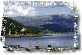
Bindal is a municipality in the Helgeland region in the extreme southwest part of Nordland county, Norway. The administrative centre is the village of Terråk. Other villages include Bindalseidet, Holm, Vassås, Horsfjord and Åbygda.
Contents
- Map of Bindal Norway
- General information
- Name
- Coat of arms
- Churches
- Geography
- Government
- Municipal council
- Economy
- Culture
- Education
- References
Map of Bindal, Norway
General information
In 1838, the parish of Bindal was split into two municipalities (see formannskapsdistrikt) because the parish included land in both the counties of Nord-Trøndelag and Nordland. The new law required that municipalities be located only in one county, so the parish was divided into two municipalities: Nordbindalen and Sørbindalen. In 1852, the county border was moved south to its current position and the municipalities of Nordbindalen and Sørbindalen were merged back together to form the municipality of Bindal. On 1 January 1964, the Tosen-Lande area (population: 296) was transferred to Brønnøy.
Name
The Old Norse form of the name was Birnudalr. The first element is the genitive case of the river name Birna (now Åbjøra) and the last element is dalr which means "valley" or "dale". The river name is derived from the word birna which means "(female) bear".
Coat-of-arms
The coat-of-arms is from modern times (1990). The arms show six gold rivets on a blue background to represent the boat building industry in the municipality.
Churches
The Church of Norway has two parishes (sokn) within the municipality of Bindal. It is part of the Sør-Helgeland deanery in the Diocese of Sør-Hålogaland.
Geography
Bindal borders four municipalities in Nord-Trøndelag county: Høylandet and Nærøy in the south, Namsskogan in the southeast, and Leka in the west. Bindal also has borders with the Nordland municipalities of Sømna, Brønnøy, and Grane. The Bindalsfjorden runs through the central part of the municipality.
From the coast, the municipality reaches into the mountains towards the lake Majavatnet in Grane. The tallest mountain is the 1,058-metre (3,471 ft) tall Heilhornet. It also includes part of the lakes Eidevatnet and Fjellvatnet, which also partially lie in Brønnøy municipality. Other lakes include Åbjørvatnet, Kalvvatnet, and Saglivatnet. The river Åbjøra runs through the eastern part of Bindal. Part of the island of Austra is in Bindal.
Government
All municipalities in Norway, including Bindal, are responsible for primary education (through 10th grade), outpatient health services, senior citizen services, unemployment and other social services, zoning, economic development, and municipal roads. The municipality is governed by a municipal council of elected representatives, which in turn elect a mayor.
Municipal council
The municipal council (Kommunestyre) of Bindal is made up of 17 representatives that are elected to every four years. Currently, the party breakdown is as follows:
Economy
The most important industries in Bindal are aquaculture, farming and forestry.
Culture
Boat races for Nordland boats are have been held annually since 1978 in the main village of Terråk during the last weekend of June. Bindal has a traditional boat-building industry and Nordland boats are still manufactured here.
Education
Bindal has two schools; one of them is classified as independent and therefore not administered by the municipality.