Population 228,175 (2001) Language spoken Kannada Area 10.541 km2 | State Karnataka District Bijapur District | |
Colleges and Universities Karnataka State Womens University, Al-Ameen Medical College, Blde Societys Medical College | ||
Vijayapur city, formerly Bijapur, is the district headquarters of Bijapur District of Karnataka state. It is also the headquarters for Bijapur Taluka. Bijapur city is well known for its historical monuments of architectural importance built during the rule of the Adil Shahi dynasty. Bijapur is located 530 km northwest of Bangalore and about 550 km inland from Mumbai, and 384 km west of the city of Hyderabad.
Contents
- Map of Bijapur
- Bijapur india
- Sainik school bijapur anniversary guest indoor stadium gol gumbaz16 sept 2014
- History
- Attractions and Tourism
- Agriculture
- References
Map of Bijapur
Bijapur urban population as per 2011 census is 326,000, perhaps the 9th biggest city in Karnataka. Bijapur Mahanagara Palike(BMP) is the newest Municipal Corporation formed under the KMC act along with Shivamogga and Tumakuru Municipal Corporations. The other existing city corporations in Karnataka state in descending order of population are Bengaluru, Hubballi-Dharawada, Mysuru, Kalaburgi, Belagavi, Mangaluru, Davangere and Ballari. Administratively, Bijapur district comes under Belgaum division along with Bagalkote, Belgaum, Dharwad, Gadag, Haveri and Uttara Kannada (Karwar) districts.
Bijapur india
Bijapur, the land of five rivers and the domain of different cultures, is an ancient city. The city established in the 10th and 11th centuries by the Chalukyas of Kalyani was known as Vijayapur (City of victory). Bijapur was the biggest district place of the state with 11 taluks, but the partition of the district in 1997 made it to lose that title. Now it consists of five taluks viz. Basavan Bagevadi, Bijapur, Indi, Muddebihal and Sindagi.
Sainik school bijapur anniversary guest indoor stadium gol gumbaz16 sept 2014
The city was established in the 10th-11th centuries by the Kalyani Chalukyas and was known as Vijayapura (City of victory). The city was passed to Yadavas after Chalukyas demise. The city came under the influence of the Khilji Sultanate in Delhi by the late 13th century. In 1347, the area was conquered by the Bahmani Sultanate of Gulbarga. By this time, the city was being referred as Bijapur. Bijapur, Karnataka. Ironically the name Beejpur literally means replete with seeds in Sanskrit, meaning Pomegranate. Beejpur is a hindi word and does not exists in sanskrit .
History

In 1518, the Bahmani Sultanate split into five splinter states known as the Deccan sultanates, one of which was Bijapur, ruled by the kings of the Adil Shahi dynasty (1490–1686). The city of Vijayapura owes much of its greatness to Yusuf Adil Shah, the founder of the independent state of Bijapur. The rule of this dynasty ended in 1686, when Bijapur was conquered during the reign of Mughal emperor Aurangzeb. In 1724 the Nizam of Hyderabad established his independence in the Deccan, and included Bijapur within his dominions. In 1760, the Nizam suffered a defeat by the Marathas, and ceded the region of Bijapur to the Maratha Peshwa. After the 1818 defeat of the Peshwa by the British in the Third Anglo-Maratha War, Bijapur passed into the hands of the British East India Company, and was assigned to the princely state Satara.
Bijapur district is historically, traditionally and legendarily, one of the richest districts in the state. The evidence found here reveals that it was an inhabited place since the Stone Age. Many places of this district have legendary history. The history of this district is divided into four periods, from the Chalukya acquisition of Badami till the Muslim invasion.

Bijapur came under Muslim influence, first under Allaudin Khilji, the Sultan of Delhi, towards the end of the 13th century, and then under the Bahamani kings of Bidar in 1347. In 1347, when the Bahamani dynasty was established, it included southern and eastern parts of Bijapur district. The supremacy of the Bahamans may be said to have ceased by 1489. At that time five Shahi Dynasties were born and one of them was „Bijapur?. The Mughal emperor Aurangajeb conquered Bijapur in 1686 and it was under Mughal rule up to 1723. In 1724 the Nizam of Hyderabad established his independence in the Deccan and included Bijapur within his dominions. However, his acquisition on this portion was of brief duration, in 1760 it went into the hands of Marathas. In 1817, war broke out between the British and the Marathas. By 1818, the whole of Bijapur was occupied by the British and was included in the territory assigned to the Raja of Satara. In 1848 the territory of Satara was obtained through the failure of heir and the British rule started. Till 1884, the Bijapur district was known as „Kaladagi? district and the headquarters of the district was also at Kaladagi. (Now it is Bagalkot district). Bijapur was made headquarters in1885. After Independence, the movement for re-organisation of States gained further momentum and on 1 November 1956 a separate „Mysore State? was formed. By the wish of the people it was renamed as „Karnataka?. Thus, the district Bijapur along with other Kannada speaking areas became a part of „Karnataka State? on 1 November 1973.
In 1848 the territory of Satara, along with Bijapur, was annexed to Britains Bombay Presidency when the last ruler died without a male heir. The British carved a new district by the name Kaladagi. The district included present-day Bijapur and Bagalkot districts. Bijapur was made the administrative headquarters of the district in 1885, when the headquarters were moved from Bagalkot. After Indias Independence in 1947, the district became part of Bombay state, and was reassigned to Mysore State, later Karnataka, in 1956.Center government have approved the request to rename the city in October 2014 and Bijapur is renamed (along with other 12 cities) to "Vijayapura" on November 1, 2014.
Attractions and Tourism

In an introduction to an album of Bijapur published in 1866, Philip Meadows Taylor wrote: “Palaces, arches, tombs, cisterns, gateways, minarets, ...all carved from the rich basalt rock of the locality, garlanded by creepers, broken and disjointed by peepul trees, each in its turn is a gem of art and the whole a treasury.”
Gol Gumbaz
This is the most famous monument in Bijapur. It is the tomb of Mohammed Adil Shah (ruled 1627-1657). It is the largest dome ever built in India, next in size only to St Peters Basilica in Rome. A particular attraction in this monument is the central chamber, where every sound is echoed seven times. Another attraction at the Gol Gumbaz is the Whispering Gallery, where even minute sounds can be heard clearly 37 metres away. Gol Gumbaz complex includes a mosque, a Naqqar Khana (a hall for the trumpeters) (Now it is used as museum) and the ruins of guest houses.
The Archaeological Museum
It has several curious objects like inscriptions, sculptures, paintings, manuscripts, and weapons etc., displayed. It is near Gol Gumbaz and is run by the Archaeological Survey.
Ibrahim Rauza
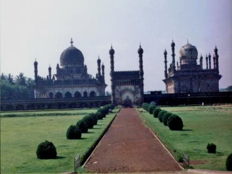
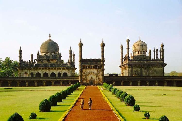
This is the tomb of Ibrahim Adil Shah II (ruled 1580-1627), the fifth king of the dynasty and, like the Mughal emperor Akbar, known for religious tolerance. Built on a single rock bed, it is noted for the symmetry of its features. It is said that the design for the Ibrahim Rauza served as an inspiration for that of the famous Taj Mahal.
King Edward VII Memorial
In British India, a tower with a marble structure with a bust of King Edward VII and a park around the tower were established in memory of King Edward VII, Emperor of India. The memorial is situated in the heart of the city, and the foundation stone for the memorial was laid on 2 November 1913 by Lord Hardinge, Viceroy of British India. Built in the Indo-Islamic architecture, the memorial served as an attraction for children. The memorial once had beautiful fountains and taps providing drinking water. It was the equivalent of Bangalores Cubbon Park or Lalbagh for the residents of Bijapur. However, mismanagement by government in the 1970s resulted in the destruction of the park. There was a proposal to demolish the memorial, and establish a deer park, and then a Ranga Mandira. All these projects were not successful, and only resulted in destruction of the park. On the site of park, a godown, Kandagal Hanamantharaya Ranga Mandira, district Lokayukta office and Information?Department buildings have been constructed, and the memorial has been reduced to only a few feet. Today, there is no sign of the beautiful park, which once stood, and the neglected statue of King Edward VII stands testimony to the neglected heritage.
Malik-e-Maidan (The Monarch of the Plains)
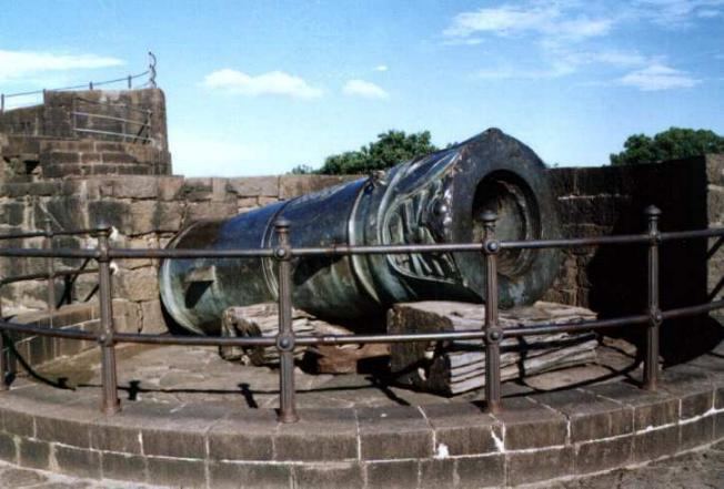
The largest medieval cannon in the world. Being 4 m long, 1,5 m in diameter and weighing 55 tons, this gun was brought back from Ahmadnagar in the 17th century as a trophy of war by 400 oxen, 10 elephants and tens of men. It was placed on the Sherza Burj (Lion Gate) on a platform especially built for it. The cannons nozzle is fashioned into the shape of a lions head with open jaws & between the carved fangs is depicted an elephant being crushed to death. It is said that after igniting the cannon, the gunner would remain underwater in a tank of water on the platform to avoid the deafening explosion. The cannon remains cool even in strong sunlight and if tapped, tinkles like a bell. In 1854 the cannon was auctioned for Rs. 150 but the sale was cancelled in the end.
Upli Buruj
Built around 1584 by Hyder Khan, is an 80 ft (24 m) high tower standing to the north of Dakhani Idgah in Bijapur. This is a spherical structure with stone steps winding round the outside. Top of the tower offers a commanding view of the city. This is also known as Hyder Burj, Upli Burj. On top of Upli Burj there are two guns of huge size. The parafeet this tower which was used for monitoring purposes has been fenced now. One needs to climb the circular stairs to reach the top. However except for this tower there is very little evidence of the citadel wall in this area due to rampant construction.
Chand Bawdi
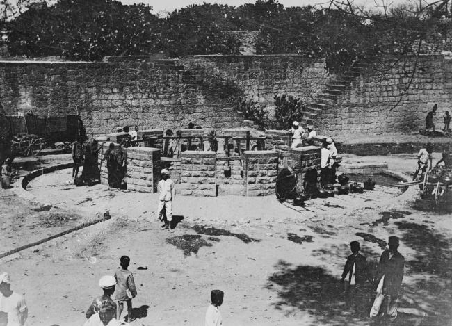
Ali Adil Shah (1557–1580) built this tank near eastern boundary of Bijapur. When there was large influx of people into Bijapur after the fall of the Vijayanagar empire, and new settlements came up within the walled city raising the need for better infrastructure and providing water supply. This has a storage capacity of 20 million litres. Later it became a model for many other tanks constructed in the city. A grandeur complex came up around it, which was mainly used to house the maintenance staff though members of the royal family occasionally used it for recreation. He named this after his wife "Chand Bibi".
Asar Mahal
The Asar Mahal was built by Mohammed Adil Shah in about 1646, which was used to serve as a Hall of Justice. The building was also used to house hairs from the Prophets beard. The rooms on the upper storey are decorated with frescoes and the front is graced with a square tank. Here women are not allowed inside. Every year there is urs (festival) held at this place. In front of the hall, one can see three tanks the bigger tank, which is at the centre is about 15 feet (4.6 m) deep however the other two are comparatively smaller in size as well as depth. Behind Asar Mahal one can still see the remain of the citadel. Just a kilometer away behind Asar Mahal, one can still find the old mosque which is on top of the citadel wall. There is a big entrance with arc below this mosque. Many stones have inscriptions. The site is under maintenance of Archeological Survey of India.
Gagan Mahal
Which means Sky Palace, is built with a 21- meter facade and four wooden massive pillars, has a majestic central arch. Sikandar Adil Shah, in silver chains, surrendered to Aurangzeb in 1681 here.
Barakaman (Ali Roza-II)
A mausoleum of Ali Roza built in 1672. It was previously named as Ali Roza, but Shah Nawab Khan changed its name to Bara Kaman as this was the 12th monument during his reign. It has now seven arches and the tomb containing the graves of Ali, his queens and eleven other ladies possibly belonging to the Zenana of the queens.
Saat Kabar
Meaning sixty graves, is a site which can aptly be called as the dark tourist spot. Saat Kabar may not have any intricate or wonderful architectural characteristics like the Gol Gumbaz or Ibrahim Roza to offer to its visitors, but the heart-rending story it narrates makes it a spot worth visiting. This heritage site tells the story of a passionate army chief who killed his 63 wives fearing they would remarry after his death. Afzal Khan, the army chief of Ali Adil Shah II of the Adil Shahi Dynasty that ruled Bijapur for four centuries, cold bloodedly murdered all his wives, one by one, before setting out on a battle with Chhatrapati Shivaji Maharaj, the great Maratha warrior, at Pratapgad in Maharashtra in 1659. Sick of continuous attacks by Aurangzeb on one side and Chhatrapati Shivaji Maharaj on the other side, Ali Adil Shahi-II ordered Afzal Khan to contain these two enemies to protect the empire. Although known for his bravery, Khan was a firm believer in astrology. He always consulted soothsayers before setting out on a war. When an astrologer predicted about his defeat and sure death in the battle against Chhatrapati Shivaji Maharaj, he decided to kill all his wives so that they would not remarry after his death. Hence he led all his wives to a huge well in a lonely place on the outskirts of the city and pushed them into it one after another. Later, he buried their bodies near the well. Seeing this horrifying act, two of his wives tried to escape, but in vain. They were chased and killed by soldiers, reveal historical records.
Ibrahim Rauza
It is situated on the western outskirts of the city. Ibrahim Rauza comprises two buildings, a magnificent tomb and a remarkable mosque enveloped by a garden. Facing each other, these twin buildings have a fountain in between them. A Persian inscription here records the construction of this Rauza in 1626. These buildings stand on a raised terrace supported by arches in a large rectangular enclosure with a high entrance tower in the centre of the north side, adorned with four graceful minarets. This is the most ornate building in Bijapur. Both the buildings have square plans with four minarets at the corners and a bulbous dome at the centre, which emerges from lotus petals. Cousins called the building as “The Taj Mahal of the Deccan”.
Malik-Karim-ud-dins
Mosque is standing at the east of the Chini Mahal. The mosque appears to be a Hindu temple originally. An inscription inside the pillar in old Kannada characters dated 1320 A.D. says the name of the builder of the upper part as Ravayya of Salotgi. It is a rectangular enclosure with a fine vestibule in front, the portico of which spreading into wings fills the forepart of the mosque. According to another version, earlier it was a Hindu college, converted into a mosque.
Jami Masjid
It is the largest and oldest mosque in the Deccan. It is at 1200 yards to the east of the citadel. Ali Adil Shah I, after his triumphant victory over Vijayanagara built this mosque. It is a mosque, rectangle in shape, about 400 feet (120 m) from east to west and 280 feet (85 m) from north to south. The main entrance is from the east side and there is a pavilion ascribed to Aurangzeb at the entrance. Including the entire big open court spread between two wings, the mosque occupies an area of 116,300 square feet (10,800 m2) and unmatched by any building in Bijapur. The columns in the main building divide the floor into 45 equal squares. The most beautiful feature is the dome of this building which is highly proportionate. The mihrab here is gorgeously painted.
Jod Gumbaz
It is behind the Government High School. A pair of tombs is housed in this. The floors of both the tombs are at a very considerable elevation, as the graves have been built at floor level. Both the buildings have galleries within the domes. Afzal khan’s cenotaph is at a distance of about four km from the gate way of Shahapur. There is a mosque too. Afzal khan commenced the construction of his own splendid tomb in his lifetime. But he was not buried in the tomb. About one km towards south of Afzal khan’s tomb are his wives’ tombs on a masonry platform consisting of 11 rows of graves. There are 63 graves and one is empty. It is said that Afzal Khan believed in one astrologer’s prediction that he would never return to Bijapur when he went to meet Chhatrapati Shivaji Maharaj, and had all his 64 wives drowned before his journey, except one who escaped. That is how one grave is empty.
Green Stone Sarchophagus
It is a tomb at a little distance to the south of Ali I’s tomb. It is finely cut and molded in a dark greenish black-basalt, standing on a raised large platform. The name of the buried person is not known.
Jala Manjil
It is a small tidy square structure, to the north of the Sat-Manzil standing in the middle of a dry reservoir, which was exclusively meant as a pleasure spot for the royal family.
Landa Kasab Gun Lies in the middle of the southern fort of the City. It weighs about 46.5 tons, and there is another small gun on the same bastion. Though unprotected for 300 years from the rig ours of climate, these guns show no signs of decay.
Malik-i-Maidan
The great gun of Bijapur, is placed to the north of Phatka gate in a tower. This is the biggest gun in Bijapur, weighing about 55 tons and was cast at Ahmednagar in 1549 by a Turkish Officer in the service of Burhan Nizamshah and this information is engraved on it. The muzzle is fashioned into the form of the head of a lion or dragon.
Sat-Manzil
It is part of the mansion that now remains to the west of the citadel. In this dilapidated five-storeyed building are traces of painting, and stucco work has been executed on the ceiling of the different floors.
Taj Bavadi
To the west of the Mecca gateway, about 100 yards away is Taj Bavadi. The well is 223 feet (68 m) in square and 52 feet (16 m) deep.
Mehatar Mahal
It is about 260 yards to the south of the Jumma Masjid-Ark-killa road. Actually it is not a palace but an ornamental gateway which leads to a mosque and garden. Its flat stone roof has been a puzzle to engineers, which is supported by delicately carved stone brackets of birds.
Chand Bavadi
It has a lone tower called Upari Buraz situated on a high ground. It was built in 1584 A.D. and on it placed are two guns.
Malika Jahan Begam’s Mosque
It is stands about 100 yards west of the citadel, built by Ibrahim Adil Sha II in honour of his wife Mallika Jahan Begam. The columns of the arches are very fine and the stucco work is very good.
Malik Sandals Mosque
It stands about 75 yards north of Bukhara Mosque. It is a peculiar combination of Hindu-Muslim architecture. The roof is borne not on arches but on eight-sided columns with Hindu pedestals and capitals. The construction is in Hindu style except the central dome and the western mihrab.
Mecca mosque
It is situated near the middle of the citadel. It is one of the finest and smallest mosques here. It appears to belong to the period of Ibrahim II.
Shanmukhasvami Matha
It is located near the great Gol Gumbaz. It was founded by Saint Shanmukhaswami. A big front hall surrounded by an open yard has a cellar containing the Samadhi of Shanmukhaswami.
Narasimha temple
It is a highly revered temple situated on the west centre of the citadel on the inner most under a papal tree. It is being popularly called as Narasoba or Narasimha temple. The chief object of worship is a shapeless black stone in the form of Dattareya. A pair of sandals or padukas said to belong to Saint Narasimha Saraswathi are worshipped there. It is said to be frequented by Ibrahim Adil Shah II.
Parshwanath Basadi
About 3 km from the city near the dargah is a basadi of Parshwanath. The black stone idol is about 3 feet (0.91 m) high and of beautiful workmanship. A serpent with 1008 small hoods spread over the deity as umbrella is delicately carved. Some years back while digging a mound, the figure is stated to have been unearthed.
Torvi Narasimha Temple
Torvi is located merely 5 km from Bijapur.The Narasimha temple, which is built underground is very close to Adil Shahis Sangeeth mahal. Nearby this temple, another Hindu temple of Devi Lakshmi is located.The people of Bijapur have a trend to visit these temples every Saturday.
Shree Siddeshwar Temple
Shree Siddeshwar Temple is located in heart of the city. It is on behalf of Solapur Shree Siddarameshwar of Basavs Saints (Sharanas).
Basavan Bagewadi
Basavan Bagewadi is birthplace of Lord Basavanna.Here beautiful Nandi Temple had constructed in 11th century. It is under management of Kudal Sangam Development Authority.
Alamatti Dam (Lal Bahaddur Shastri Sagar)
Alamatti Dam is situated in NH -13 border of Bijapur-Bagalkot twin Districts of Karnatak State. It is a best tourist place in Bijapur District.
Agriculture
In Bijapur district agriculture forms the important source of livelihood for the most of the people. The population of the district according to 2001 census is 18, 06,918 of which 7, 18,213 are workers and 10, 88,705 are non-workers.Of the former category, 5,03,755 persons (2, 17,056 cultivators + 2, 86,669 agricultural labourers) are engaged in agriculture, forming 70.1 percent of the total working population.

Due to the untimely and inadequate nature of rainfall, Bijapur district has frequently suffered from famines and droughts. Though the district is being drained by five rivers, the area under irrigation is very small compared to 104 geographical area and the net area sown with agricultural crops. The total area sown is 8,42,586 hectares, out of which only 1, 98,614 (23.5%) hectares is irrigated.
