
- elevation 582.7 ft (177.6 m) - elevation 495 ft (150.9 m) | - elevation 793.6 ft (241.9 m) | |
 | ||
- location W of summit, N of stone bridge Owner Federal government of the United States Biome Northeastern coastal forests | ||
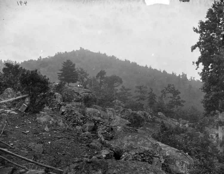
Big Round Top is a boulder-strewn hill notable as the topographic high point of the Gettysburg Battlefield and for 1863 American Civil War engagements for which Medals of Honor were awarded. In addition to battle monuments, a historic postbellum structure on the uninhabited hill is the Big Round Top Observation Tower Foundation Ruin.
Contents
- Map of Big Round Top Cumberland Township PA 17325 USA
- Geography
- History
- Civil War
- Postbellum
- Observation Tower
- Destruction
- References
Map of Big Round Top, Cumberland Township, PA 17325, USA
Geography
Big Round Top is the southern peak of the Gettysburg Battlefield and is within the area encompassed by a drainage depression (southeast, south), Plum Run (west, north), and the Crawford Rd/Wright Av roadway (north, northeast). In addition to Little Round Top, adjacent battlefield locations are South Cavalry Field/Slyder Field (west), Devil's Den (northwest) and the Valley of Death/Slaughter Pen (north). The hill is the highest point of an Adams County dendritic ridge which Plum Run divides at Big Round Top (the drainage divide continues to the east). In addition to Little Round Top (650), nearby heights are Warfield Ridge (west), hills of ~580 ft (southwest) and ~540 ft (northwest), and Houck Ridge (north-northwest); while Carr Hill (876 ft) is the nearest higher hill. "Devil's Kitchen" is rock formation and small cave on the lower slopes of Big Round Top.
History
The igneous hill was formed 200 million years ago when the "outcrop of the Gettysburg sill" intruded through the Triassic "Gettysburg plain". Subsequent periglacial frost wedging during the Pleistocene formed the hill's extensive boulders. Early human activity included Indigenous people clearing an area on the slope of Big Round Top and established a burial ground ~1 mile southwest.[4][5] prior to the 1736 British purchase of the region.
Civil War
Privately owned during the Battle of Gettysburg, Big Round Top's slope, timber, and boulders precluded placement of artillery on the summit. At various times during the 1863 battle, positions on Big Round Top formed the left flank of the Union defense. No fighting or other actions took place on Big Round Top on July 1.
By September 1863, David McConaughy had begun to acquire a portion of Big Round Top for battlefield preservation. The Elon J. Farnsworth monument was erected before 1896 at the base of Big Round Top, and statues of William Wells (1931) and John Michael Tobin are also on the hill.
Postbellum
Kilpatrick Avenue had been completed at the west base of Big Round Top by 1895 when the gravel South Confederate Avenue was constructed across the northwest slope. In 1903, Wright Av was constructed along the northeast slope, and in 1937, S Confederate Av and the Plum Run stone bridge were rebuilt [7][8] for the 75th battle anniversary and reunion. In 1940, Seminary Ridge CCC workers rerouted the stone trail to the Big Round Top summit, and Harry Truman visited Big Round Top in 1946.[9] In 1964, the Big Round Top Nature Trail was created around the hill and provided access to the Devil's Kitchen.[10] The 1895 Big Round Top Observation Tower was dismantled in 1968 and the foundation was named a historic ruin in 2004.
Observation Tower
The tower was built in the late 19th century. Fred Lyons of Baltimore led the construction team that moved the foundation's granite blocks to the Big Round Top summit using block and tackle driven by a 12-horsepower engine. Constructed on the Gettysburg Battlefield's highest hill, the Big Round Top tower was to be replaced for the 1938 anniversary reunion by a stone "Gettysburg Peace Memorial" with a 75-foot-high observation deck above the summit and a flame 30 feet higher.
a. - (January 30, 1937). "Measure Calls for Creation of $100,000 Fund; Eternal Light To Be Built on Battlefield and Dedicated at Anniversary and Reunion in 1938" (Google News Archive). Retrieved 2010-03-20. a. (The memorial was instead erected on Oak Hill.)Destruction
During 1968 tower maintenance, the Schlesser Demolition Co dismantled the Big Round Top tower as uneconomical due to "its condition and the very limited use [due to an uphill, lengthy, and serpentine trail.] Most who started the climb gave out en route, and upon reaching the tower decided against continuing the climb to the top of the metal observatory" (GNMP Superintendent George F. Emery). The foundation ruin (park structure RU05) of the "national landmark" tower, was "entered-documented" as a historic site on January 23, 2004.