
Countries Canada, United States Country United States of America | River mouth 1,900 feet (580 m) River system Missouri River | |
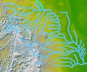 | ||
Big Muddy Creek is a tributary of the Missouri River, approximately 191 mi (307 km) long, in the Canadian province of Saskatchewan and the U.S. state of Montana. It flows through the Big Muddy Badlands.
Contents
Map of Big Muddy Creek, Montana, USA
It rises in southern Saskatchewan at Willow Bunch Lake, on the plains north of the international border and approximately 20 mi (32 km) northwest of Big Beaver. It flows southeast through the Big Muddy Badlands and through Big Muddy Lake, then south into Sheridan County, Montana, past Redstone, then east, past Plentywood, then south, forming the eastern border of Fort Peck Indian Reservation. It joins the Missouri west of Culbertson.
It was explored in 1805 by the Lewis and Clark Expedition, who called it Martha's River in their journals and noticed on their return voyage in 1806 that it had changed its mouth on the Missouri.
Along with the Milk River and the Poplar River, it is one of three waterways in Canada that drain into the Gulf of Mexico.
Variant names
Big Muddy Creek has also been known as: Big Muddy River, Little Yellow River, Martha River, Martha's River, Marthas River, Marthy's River and Park River.