
Topo map USGS Big Hole Pass Range Rocky Mountains | Elevation 2,243 m Traversed by Continental Divide Trail | |
 | ||
Location Beaverhead-Deerlodge National Forest, Beaverhead County, Montana and Salmon National Forest, Lemhi County, Idaho | ||
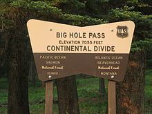
Big Hole Pass (el. 7,055 feet (2,150 m)) is a high mountain pass on the Montana Idaho border approximately 8 miles due south of Montana State Highway 43 in the Beaverhead-Deerlodge National Forest, Beaverhead County, Montana and Salmon National Forest, Lemhi County, Idaho. This location should not be confused with a sign on Montana Highway 278 at the height of land west of Dillon, Montana that denotes the eastern entrance to the Big Hole valley. The Continental Divide Trail goes over this pass which is about 11 miles south southeast of the more famous Chief Joseph Pass. The Pass can be approached on a Forest Service road, Dahlonega Creek Road (079), from the west, or Forest Service Road #943 from Highway 43 from the east. On their return trip the Lewis & Clark Expedition separated at Travelers Rest in Idaho. On July 3, 1806, Meriwether Lewis headed north to explore the Marias River while William Clark headed up the Bitterroot River with 50 men, Sacagawea and her baby. They crossed Big Hole Pass on their way to their cache of supplies at Camp Fortunate.
Contents
Map of Big Hole Pass, Idaho 83463, USA
RecreationEdit
This pass can't be seen from a paved highway, but is frequently traversed by thru-hikers on the Continental Divide Trail (CDT). Hunters, fishermen and other outdoors people use the area. Within a mile of Big Hole Pass, a woods road sits on the actual Continental Divide. Water draining from the muddy road on the left goes toward the Pacific Ocean while water on the right goes toward the Atlantic Ocean.