
Elevation 8,356 ft (2,547 m) Width 8 mi (13 km) Country United States of America | Length 18 mi (29 km) NW-SE | |
 | ||
Borders on Little Hatchet Mountains-NNWHatchita Valley-N & NEPlayas Valley-NW, W & SWAlamo Hueco Mountains-S Similar Big Hatchet Peak, Animas Mountains, Florida Mountains, Caballo Mountains, Robledo Mountains | ||
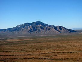
The Big Hatchet Mountains are an 18 mi (29 km) long, mountain range in southeast Hidalgo County, New Mexico, adjacent the northern border of Chihuahua state, Mexico.
Contents
- Map of Big Hatchet Mountains New Mexico 88040 USA
- DescriptionEdit
- Geology ecology and accessEdit
- HighpointsEdit
- Continental Divide National Scenic TrailEdit
- References
Map of Big Hatchet Mountains, New Mexico 88040, USA
The range lies just south of a westerly excursion of the Continental Divide of the Americas; it lies on the eastern perimeter of the extensive, narrow, and north-south Playas Valley, and is the center range of three mostly arid, low to moderate-elevation ranges that lie on the valley's east perimeter. The mountain range lies in the extreme northwest of the Chihuahuan Desert.
DescriptionEdit
The range is 18 mi long and only about 8 mi wide. It trends northwest by southeast as does the Alamo Hueco Mountains to the south; the Little Hatchet Mountains bordering the range northwest, trend similarly, but have a more true north traverse.
Geology, ecology, and accessEdit
Geologically this range is part of the Basin and Range Province which spans much of the southwestern U.S. and parts of northern Mexico. It is a fault-block range made up of Paleozoic limestone and Cretaceous shale and sandstones.
Ecologically, the Big Hatchet Mountains lie near the Chihuahuan Desert and the Sonoran Desert, but their large relief provides many ecological niches more in keeping with the mountains to the north. Notable inhabitants include bats, raptors, bighorn sheep, and javelina.
The Big Hatchet Mountains are far from population centers, and have no paved road access or developed recreation sites; they therefore see little recreational activity other than long-distance hikers who are either starting or completing the Continental Divide Trail. However, the standard route on the peak, along the South Ridge from Thompson Canyon, is straightforward.
HighpointsEdit
The highest peak in the range, Big Hatchet Peak, 8,366 feet (2,550 m), is at the northwest terminus of the range; the peak is located at 31°38′07″N 108°23′56″W. Another peak anchors the southeast terminus of the range, New Well Peak, at 6,284 feet (1,915 m).
Continental Divide National Scenic TrailEdit
The Continental Divide lies north of the Big Hatchet Mountains and traverses the northern Playas Valley on its water divide. The Continental Divide National Scenic Trail (CDT) is routed through the Big Hatchet's on two alternative trails, one at the center and the other in the north; also subtrails lead off in a southeasterly direction. The main traverse of the CDT exits from the southwest quarter of the range, to meet the northwest end of the Alamo Hueco Mountains.