
Topo map USGS Silverton Prominence 329 m | Elevation 1,878 m | |
 | ||
Similar Vesper Peak, Sloan Peak, Monte Cristo Peak, Del Campo Peak, Mount Pugh | ||
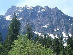
Big Four is a mountain in the Cascade Range, located about 20 miles (32 km) east of Granite Falls, Washington. Debris piles on the mountain's northern flank form as a result of avalanche activity. These fields of disturbed snow are able to remain year round in the shadow of the mountain. During the summer months snow-melt streams flow beneath the debris piles and cause caves to form in the ice. The caves vary in size from season to season and are unpredictably dangerous. The mountain is open to the public and a large snowfield can be reached by a short trail, but the snowfield itself is off-limits due to cave-ins and slides which have killed hikers in incidents in 1998, 2010, and 2015.
Contents
Map of Big Four Mountain, Washington 98252, USA
HistoryEdit
Big Four is not named for the five peaks on its top but either for a figure 4 that is visible in one of its snowfields, or 4 husky brothers who were prospecting and trapping in the valley.