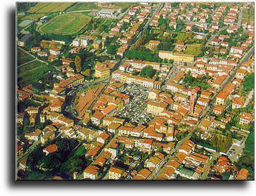
Elevation 10 m (30 ft) Time zone CET (UTC+1) Local time Wednesday 12:27 PM Postal code 56031 Dialling code 0587 | Demonym(s) Bientinesi Area 29.2 km² | |
 | ||
Frazioni Caccialupi, Puntone, Quattro Strade, Santa Colomba Weather 15°C, Wind W at 23 km/h, 45% Humidity | ||
Bientina (Italian: Bièntina) is a comune (municipality) in the Province of Pisa in the Italian region Tuscany.
Contents
- Map of Bientina Province of Pisa Italy
- History
- Territory
- Climate
- Religious architecture
- Civil architecture
- Roads
- Trains
- Notable people associated with Bientina
- International relations
- References
Map of Bientina, Province of Pisa, Italy
History
The toponym Bientina is attested the first time in 793 as Blentina and it probably comes from the Etruscan name Plitine.
Territory
Bientina is located between the Lucca's plain (Piana di Lucca) and the Valdarno.
It's about 50 kilometres (31 mi) west of Florence and about 15 kilometres (9 mi) east of Pisa and it borders the following municipalities: Altopascio (Province of Lucca), Buti, Calcinaia, Capannori (Province of Lucca), Castelfranco di Sotto, Santa Maria a Monte, Vicopisano.
In the communal territory there was once the largest lake in Tuscany, the Lake of Bientina.
Climate
Bientina experiences a Mediterranean Climate like other cities in Central Italy.
Being more distant from the sea, winters are usually less mild than Pisa and summers are warmer.
The climatic classification is "Zone D, 1856 GR/G"
Religious architecture
Civil architecture
Roads
Bientina is crossed by the Strada provinciale 439 Sarzanese Valdera and some secondary roads. Public transportation is performed by the company CTT Nord.
Trains
Until 1944 the town also had a train station along the former railway Lucca-Pontedera; the dilapidated building is still visible along the main road 25.
Notable people associated with Bientina
International relations
Bientina is twinned with Saint-Rémy-de-Provence since 1997
