
Region Rayalaseema Settled Century B.C. Population 38,994 (2011) | District Kurnool Time zone IST (UTC+5:30) Local time Monday 4:06 AM | |
 | ||
Weather 25°C, Wind SE at 11 km/h, 83% Humidity | ||
Bethamcherla is a census town and mandal headquarters located in Kurnool District of the Indian state of Andhra Pradesh.
Contents
Map of Betamcherla, Andhra Pradesh
Geography
Betamcherla sits at an average elevation of 400 meters (1315 feet). This high elevation largely protects the town against rain damage. The town is surrounded by lands rich in limestone, dolomite deposits, and flooring stones. These resources played a major role in Betamcherlas's economic development.
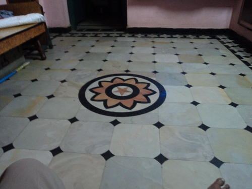
Bethamcherla is famous for the Polish stones. The mines around Bethamcherla have stones in various colours like Marble white, Buff, Joy, Green, White, Light Green Marble, Pink, Gold spot, Light green marble, etc. These stones are of 1 feet in size and will be used for enormous designs at home and office. The beauty of these slabs is they shine as you keep cleaning and are hard to break once they are laid.
Demographics
As of 2011 census, the town had a population of 38,994. The total population constitute, 19,424 males and 19,570 females —a sex ratio of 1008 females per 1000 males. 4,882 children are in the age group of 0–6 years. The average literacy rate stands at 65.60% with 22,379 literates, lower than the state average of 67.41%.
Education
The primary and secondary school education is imparted by government, aided and private schools, under the School Education Department of the state. The medium of instruction followed by different schools are English, Telugu.