
Elevation 9 m (30 ft) Postcode 5384, 5388, 5471–5476 Area 90.38 km² | Established 1 January 1994 Time zone CET (UTC+1) Area code 0412, 0413 Local time Saturday 11:34 PM | |
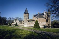 | ||
Weather 7°C, Wind W at 14 km/h, 93% Humidity Points of interest Heeswijk Castle, Meierijsche Museumboerderij, Heemschuur Maasland | ||
Bernheze ( pronunciation ) is a municipality in the southern Netherlands. It was formed in 1994 from the former municipalities of Heesch, Heeswijk-Dinther and Nistelrode.
Contents
Map of Bernheze, Netherlands
Etymology
The municipality was named after an old farm "Bernhese", which came into the possession of the Berne Abbey. This abbey was situated in the village of Bern. The meaning of 'Bernhese' is twofold: 'Bern' is the same as the old-Dutch word 'born', that means 'water' or 'well'. 'Hese' means bush or forest. In 1857 the Berne Abbey was founded in Heeswijk.
Population centres
Dutch Topographic map of the municipality of Bernheze, June 2015.
References
Bernheze Wikipedia(Text) CC BY-SA