
Length 5 km (3 mi) | Area 10 ha | |
 | ||
Status World Heritage Site (1979) | ||
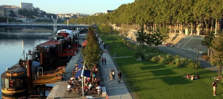
The Berges du Rhône (Banks of the Rhône) or Quais du Rhône (Quays of the Rhône) refer to a series of parks, quays, streets and walking paths along the Rhône river in Lyon, France. The construction for the modern Berges du Rhône took place between 2005 and 2007, resulting in the development of 10 hectares of land on the left and right banks of the Rhône from Parc de la Tête d'Or to Parc de Gerland.
Contents
- Map of Berges du RhC3B4ne 69007 Lyon France
- History of development
- Modern development
- The modern Berges du Rhne
- Later development
- Right bank
- Left bank
- References
Map of Berges du Rh%C3%B4ne, 69007 Lyon, France
History of development
Several dams were built during the nineteenth century to prevent flooding on the left bank of the Rhône, in particular the flood of 1856. The Grand Camp dam (digue du Grand Camp) was built in 1859.
Modern development
In 1984, the Lyon Fair was moved from its original location upstream of the quays of the Rhône near Parc de la Tete d'Or to Chassieu to become the Eurexpo. The vacant land was used to build Cité Internationale, which includes the Musée d'art contemporain de Lyon, cinemas, an auditorium, the Palais des congrès de Lyon and the global headquarters of Interpol.
The modern Berges du Rhône
The modern Berges du Rhône were developed with the aim of creating a space for relaxation and leisure activities including paths for walking and cycling along the Rhône. Space was created by eliminating parking spaces. The developed area covers an area of 10 hectares (25 acres), over a distance of 5 kilometres (3.1 miles), from Parc de la Tête d'Or to Parc de Gerland.
In 2001 the Lyon city planning agency developed a scope statement outlining the goals for the project, which included removing parking spaces and introducing flood reduction measures. The project cost was estimated to be €15.5 million at the time. In 2002 the city released the design for the project.
A development team was chosen in 2003, and a consultation phase began the same year. During the consultation phase, the municipal opposition criticized the removal of parking spaces on the banks of the Rhône and their replacement with paid parking garages. In the second quarter of 2004, the project was presented in its final version. A budget of €44 million was finalized for the project.
In 2005 work began by eliminating parking along the Rhône and constructing several dolphin structures for mooring barges. Work was completed during the 3rd and 4th quarter of 2007.
Later development
On the right bank Parc Saint-Clair was created, which stretches along the river from the entrance to Saint-Clair to Poincaré bridge.
Construction of the 220-metre (720-foot) long Passerelle de la Paix began in March 2012 and completed in 2013, linking Caluire and Cité internationale.
Right bank
The following quays were developed at the right bank of the Rhône:
Left bank
The following quays were developed on the left bank of the Rhône: