
Country Ireland Irish Grid Reference F816443 Province Connacht | Time zone WET (UTC+0) Elevation 304 m | |
 | ||
Similar Croaghaun, Céide Fields, Eagle Island - County M, Mweelrea, Nephin Beg | ||
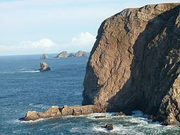
The environs of Benwee Head (Gaelic: An Bhinn Bhuí 'the yellow cliff') County Mayo, with its cliffs, arches, stacks and islands, offers some of the most dramatic coastal scenery in Ireland. These cliffs tower over Broadhaven Bay in the Atlantic Ocean and there are way-marked cliff walking trails along them for which maps can be obtained from Comhar Dún Chaocháin Teo in Carrowteige. To appreciate the cliffs fully, you need to see them from the sea. Benwee Head is in the townland of Kilgalligan in the parish of Kilcommon, Erris, a townland whose microtoponyms (field place names) and folklore traditions has been studied in detail in the 1975 book, The Living Landscape: Kilgalligan. An Bhinn Bhuí is the 1001st highest summit in Ireland and is all the more spectacular as its north sides drop vertically into the wild Atlantic Ocean. An Bhinn Bhuí is the most northerly summit in the North Mayo area.
Contents
- Map of Benwee Head Carrownaglogh Co Mayo Ireland
- The north coast of Mayo
- Dun Chaochin peninsula
- Dun Chaochain cliffs
- Stags of Broadhaven
- Walks
- Map data
- References
Map of Benwee Head, Carrownaglogh, Co. Mayo, Ireland
The north coast of Mayo
The remote and rugged north coast of Mayo is one of Ireland’s best kept secrets. Its majestic cliffs, rugged headlands, rocky coves and jagged stacks are apparent only to those willing to walk away from the main thoroughfares to discover them.
Dun Chaocháin peninsula
The Dun Chaocháin peninsula in Kilcommon parish, Erris is one of great physical beauty and has retained many of its old traditions and culture. The Irish language is still in full vigour as the vernacular.
Dun Chaochain cliffs
The spectacular Dun Chaochain cliffs have featured in various walking guidebooks and walks during the summer periods are organised by Comhar Dún Chaocháin Teo in Carrowteige, the main village on the Dún Chaocháin peninsula. Benwee Head at 255m high is the crowning glory.
Stags of Broadhaven
The Stags of Broadhaven (a group of four precipitous rocky islets rising to almost 100m) are located about 2 km north of Benwee Head and are a site of ornithological importance.
Walks
The looped walk incorporates the Children of Lir Tir Saile sculpture. The well-known legend tells the tale of children who were turned into swans and condemned to wander the countryside for 900 years. The key feature of the loop is the black ditch – a dry ditch which runs parallel to the coastline and clifftops and probably marked the boundaries of lands in previous times. The looped walks along the cliffs are marked with red, green and blue arrows according to the type of walk the individual or group wishes to follow.
Map data
Benwee Head Cliffs (Gaelic: An Bhinn Bhuí 'the yellow cliff'), County Mayo, Ireland.