
Airport type Public 18/36 4,082 Elevation 395 m | Owner City of Bentonville Elevation AMSL 1,296 ft / 395 m 4,082 1,244 | |
 | ||
Address Bentonville, AR 72712, USA Similar Northwest Arkansas Regional, Rogers Municipal Field Airp, Summit Aviation LLC, DoubleTr Suites by Hilton Hot, Walmart Neighbor Market | ||
Local flight at bentonville municipal airport vbt
Bentonville Municipal Airport (ICAO: KVBT, FAA LID: VBT) is a city-owned, public-use airport located two nautical miles (3.7 km) south of the central business district of Bentonville, a city in Benton County, Arkansas, United States. It is also known as Louise M. Thaden Field or Louise Thaden Field, a name it was given in 1951 to honor Louise McPhetridge Thaden (1905–1979), an aviation pioneer from Bentonville.
Contents
- Local flight at bentonville municipal airport vbt
- Pilot killed in crash at bentonville municipal airport
- Facilities and aircraft
- References
This airport is included in the FAA's National Plan of Integrated Airport Systems for 2009–2013, which categorizes it as a general aviation facility. Although most U.S. airports use the same three-letter location identifier for the FAA and IATA, this airport is assigned VBT by the FAA but has no designation from the IATA.
Pilot killed in crash at bentonville municipal airport
Facilities and aircraft
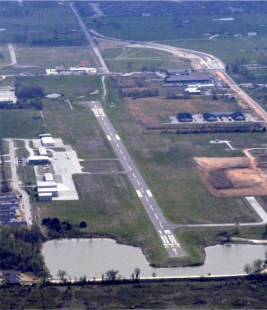
Bentonville Municipal Airport covers an area of 130 acres (53 ha) at an elevation of 1,296 feet (395 m) above mean sea level. It has one runway designated 18/36 with an asphalt surface measuring 4,082 by 65 feet (1,244 x 20 m).
For the 12-month period ending August 31, 2009, the airport had 18,100 aircraft operations, an average of 49 per day: 99% general aviation and 1% military. At that time there were 40 aircraft based at this airport: 85% single-engine, 12.5% multi-engine and 2.5% helicopter.