
Founded 1840 | Area 1,053 km² Population 8,767 (2013) Unemployment rate 4.4% (Apr 2015) | |
 | ||
Named for Senator Thomas H. Benton Website www.bentoncounty.in.gov Rivers Big Pine Creek, Mud Creek, Carpenter Creek, Sugar Creek | ||
Wind farms wind turbines benton county indiana fowler swanington
Benton County is located in the northwest part of the U.S. state of Indiana, along the border with Illinois. As of 2010, the county's population was 8,854. It contains six incorporated towns as well as several small unincorporated settlements; it is also divided into 11 townships which provide local services. The county seat is Fowler.
Contents
- Wind farms wind turbines benton county indiana fowler swanington
- Map of Benton County IN USA
- The men women of benton county indiana
- History
- Courthouse
- Economy
- Geography
- Cities and towns
- Unincorporated towns
- Extinct towns
- Townships
- Major highways
- Railroads
- Education
- Climate and weather
- Government
- Demographics
- References
Map of Benton County, IN, USA
Benton County is part of the Lafayette, Indiana, Metropolitan Statistical Area.
The men women of benton county indiana
History
Benton County was formed February 18, 1840. It is named for Thomas H. Benton (D), U.S. Senator from Missouri. The original county seat selected in 1843 was Oxford, but after a long struggle between contending factions it was moved to Fowler in 1874.
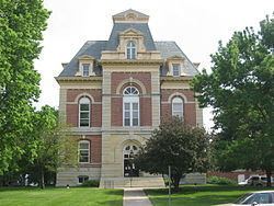
Courthouse
The current Benton County courthouse, located in Fowler, was designed by Gordon P. Randall of Chicago and built in 1874 by Levi L. Leach at a cost of $62,257. The new courthouse was an impressive building from an architectural standpoint, but also provided much-needed improvements in security, including large fire-proof vaults. Randall had designed the Marshall County courthouse a few years earlier.
Economy
In 2008 the Benton County Wind Farm began operating with 87 1.5 MW wind turbines. Duke Energy purchases electricity from the wind farm and sells it to customers through its GoGreen program.
In 2009 the Fowler Ridge Wind Farm opened nearby, giving Benton County one of the largest concentrations of wind turbines in the United States east of the Mississippi River.
Geography
Benton County's western border is shared with the state of Illinois and Iroquois County; Vermilion County is to the southwest and shares a small portion of Benton County's border. Newton and Jasper counties lie to the north, with White and Tippecanoe counties to the east. The entire southern border is shared with Warren County.
According to the 2010 census, the county has a total area of 406.51 square miles (1,052.9 km2), of which 406.42 square miles (1,052.6 km2) (or 99.98%) is land and 0.09 square miles (0.23 km2) (or 0.02%) is water.
Cities and towns
Unincorporated towns
Extinct towns
Townships
Major highways
Railroads
Education
The county's four public schools are administered by the Benton Community School Corporation.
Climate and weather
In recent years, average temperatures in Fowler have ranged from a low of 13 °F (−11 °C) in January to a high of 84 °F (29 °C) in July, although a record low of −24 °F (−31 °C) was recorded in January 1999 and a record high of 99 °F (37 °C) was recorded in July 1995. Average monthly precipitation ranged from 1.59 inches (40 mm) in February to 4.50 inches (114 mm) in June.
Government
The county government is a constitutional body granted specific powers by the Constitution of Indiana and the Indiana Code. The county council is the legislative branch of the county government and controls all spending and revenue collection. Representatives are elected from county districts. The council members serve four-year terms and are responsible for setting salaries, the annual budget and special spending. The council also has limited authority to impose local taxes, in the form of an income and property tax that is subject to state level approval, excise taxes and service taxes. In 2010, the county budgeted approximately $5 million for the district's schools and $2.8 million for other county operations and services, for a total annual budget of approximately $7.8 million.
The executive body of the county is made of a board of commissioners. The commissioners are elected county-wide, in staggered terms, and each serves a four-year term. One of the commissioners, typically the most senior, serves as president. The commissioners are charged with executing the acts legislated by the council, collecting revenue and managing day-to-day functions of the county government.
The county maintains a small claims court that can handle some civil cases. The judge on the court is elected to a term of four years and must be a member of the Indiana Bar Association. The judge is assisted by a constable who is elected to a four-year term. In some cases, court decisions can be appealed to the state level circuit court.
The county has several other elected offices, including sheriff, coroner, auditor, treasurer, recorder, surveyor and circuit court clerk. Each of these elected officers serves a term of four years and oversees a different part of county government. Members elected to county government positions are required to declare party affiliations and be residents of the county.
Each of the townships has a trustee who administers rural fire protection and ambulance service, provides poor relief and manages cemetery care, among other duties. The trustee is assisted in these duties by a three-member township board. The trustees and board members are elected to four-year terms.
Based on 2010 census results, Benton County is in Indiana's 4th Congressional District, and in 2017 was represented by Todd Rokita in the United States Congress. It is part of Indiana Senate district 6 and Indiana House of Representatives district 15.
Demographics
As of the 2010 United States Census, there were 8,854 people, 3,479 households, and 2,388 families residing in the county. The population density was 21.8 inhabitants per square mile (8.4/km2). There were 3,937 housing units at an average density of 9.7 per square mile (3.7/km2). The racial makeup of the county was 95.9% white, 0.5% black or African American, 0.2% Asian, 0.1% American Indian, 2.2% from other races, and 1.1% from two or more races. Those of Hispanic or Latino origin made up 4.9% of the population. In terms of ancestry, 32.4% were German, 17.0% were Irish, 11.3% were American, and 8.7% were English.
Of the 3,479 households, 32.5% had children under the age of 18 living with them, 54.8% were married couples living together, 9.4% had a female householder with no husband present, 31.4% were non-families, and 27.0% of all households were made up of individuals. The average household size was 2.52 and the average family size was 3.06. The median age was 40.1 years.
The median income for a household in the county was $47,697 and the median income for a family was $58,661. Males had a median income of $40,234 versus $27,957 for females. The per capita income for the county was $21,949. About 7.6% of families and 10.0% of the population were below the poverty line, including 13.6% of those under age 18 and 5.4% of those age 65 or over.