
Listing Corbett, Marilyn Elevation 841 m | OS grid NJ255354 Prominence 512 m | |
 | ||
Translation Promontory hill (Gaelic) Pronunciation Scottish Gaelic: [pejɲ ˈɾɤiɲɛʃ] Similar Ben Aigan, Ben Avon, Meall a' Bhuachaille, Beinn a' Bhùird, Bin of Cullen | ||
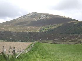
Ben Rinnes (Scottish Gaelic: Beinn Ruaidhneis) is a mountain in Banffshire, in northern Scotland. The mountain is popular with hikers with the sight from the summit that is described as truly amazing. The mountain is 20 km² in total and is located 8 km southwest of Dufftown. The mountain has one main path and can be easily accessed from the nearby car park. The Friends of Ben Rinnes program has been working on the paths to make it more accessible to the public and to prevent further erosion of the fragile ecosystem on the steep slopes and has been rather successful.
Contents
Map of Ben Rinnes, Ballindalloch, UK
View aspectsEdit
From the summit it is possible to see 8 counties (Aberdeenshire, Banffshire, Morayshire, Nairnshire, Inverness-shire, Ross and Cromarty, Sutherland, and Caithness) and on a clear day even the Moray coast. Another draw for the hiker are the waterfalls from the many rivers that flow down the mountain such as Linn of Ruthie.
Ben Rinnes hill raceEdit
A hill race has been held on Ben Rinnes for a number of years, as part of the Dufftown Highland Games. This race begins at the games field, goes over the neighbouring hills of Little Conval and Meikle Conval, then up to the summit of Ben Rinnes. Runners return by the same route. The race is 22 km long, with over 1500 m of ascent. The current record is 1:54:02, set by Robbie Simpson in the 2011 race.