
Date established 1855 | Population 3,297 (2006) North Hauraki Year established 1855 Northwest Hauraki | |
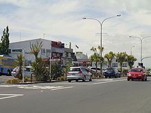 | ||
Belmont is an Auckland suburb. The name, which means "good view or hill" derives from a farm estate called "Belmont" subdivided in 1885.
Contents
Map of Belmont, Auckland 0622, New Zealand
The population of the "Seacliffe" statistical area, which is substantially the same as Belmont, was 3,297 in the 2006 Census, an increase of 162 from 2001. The suburb is in the North Shore ward, one of the thirteen administrative divisions of Auckland Council.
Education
Takapuna Grammar School is a secondary (years 9-13) school with a roll of 1587. The school was built in 1926 and opened the following year. The adjacent Belmont Intermediate is an intermediate (years 7-8) school with a roll of 518.
Belmont School is a contributing primary (years 1-6) school with a roll of 299. It was founded in 1912 and moved to its current site in 1913.
Wilson School is a special school for students with intellectual or physical disabilities. It has a roll of 65. It was previously called the Wilson Home School.
All these schools are co-educational. Wilson School has a decile rating of 9, and the other schools have decile ratings of 10.